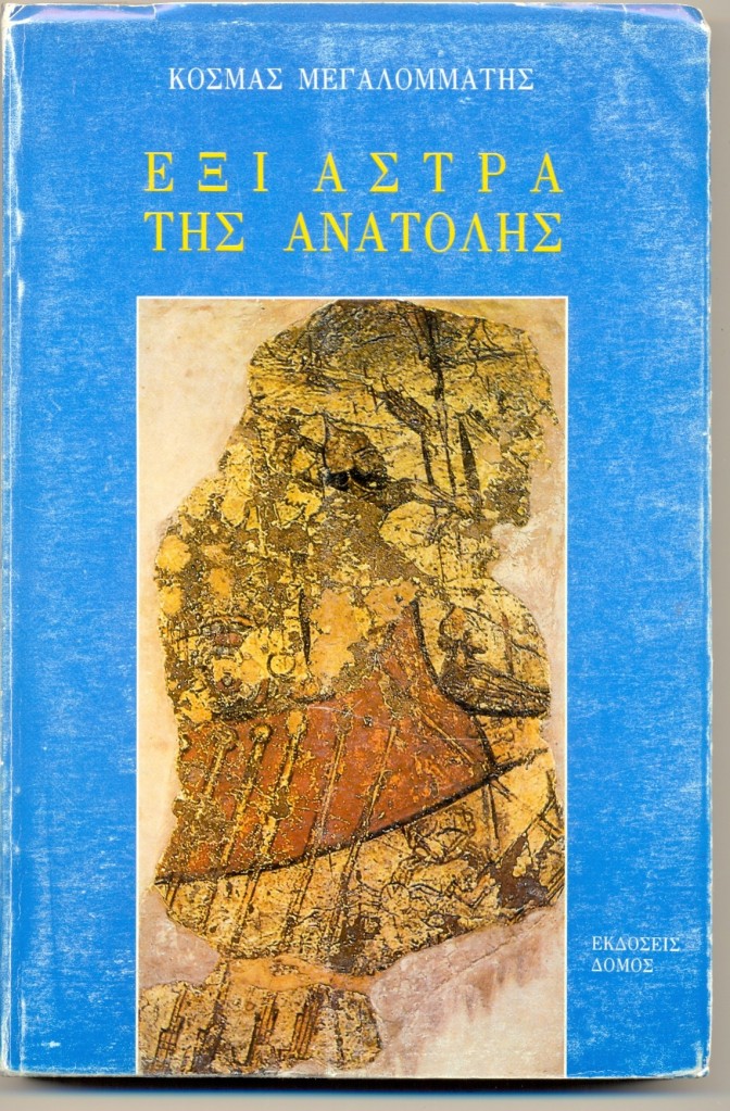
Αναδημοσιεύω εδώ το πρώτο από τα έξι κεφάλαια του βιβλίου του Έλληνα Ανατολιστή ‘Έξι Άστρα της Ανατολής’ (εκδ. Δόμος, Αθήνα, 1994). Αποσπάσματα του κεφαλαίου μαζί με επιπρόσθετες φωτογραφίες είχα αναρτήσει πριν από σχεδόν δέκα χρόνια ως βίντεο. Αναρτώ εκνέου το εν λόγω βίντεο, καθώς και το εισαγωγικό κείμενο που είχα τότε γράψει. Σε κάποιες από τις αναρτήσεις του βίντεο σε ρωσσικά σάιτς θα βρείτε αποσπάσματα από βιβλιοπαρουσιάσεις του συγκεκριμένου βιβλίου στα αγγλικά και στα ρωσσικά.
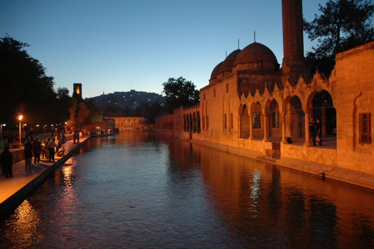
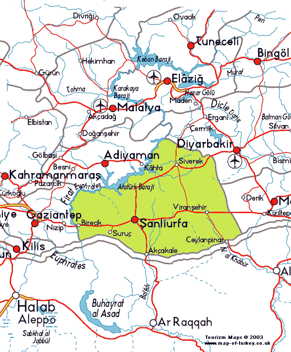
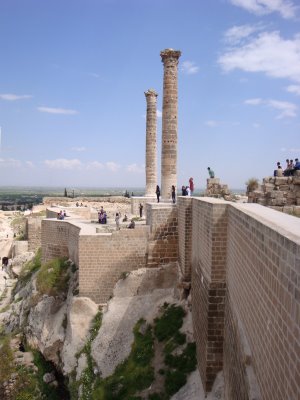
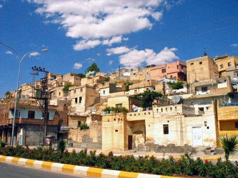
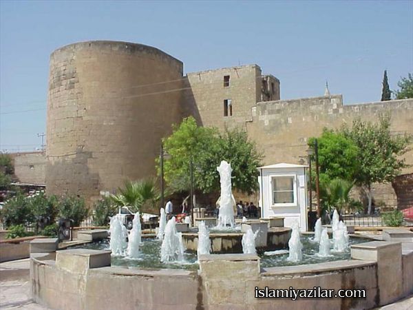
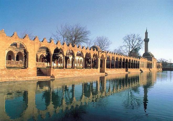
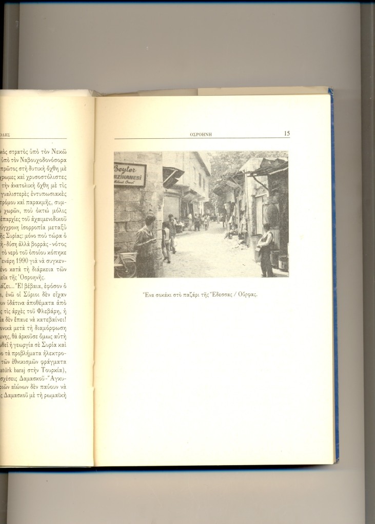
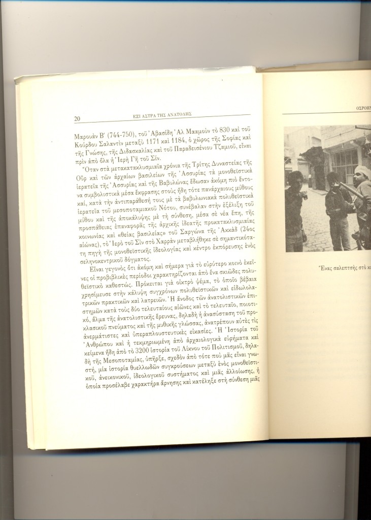
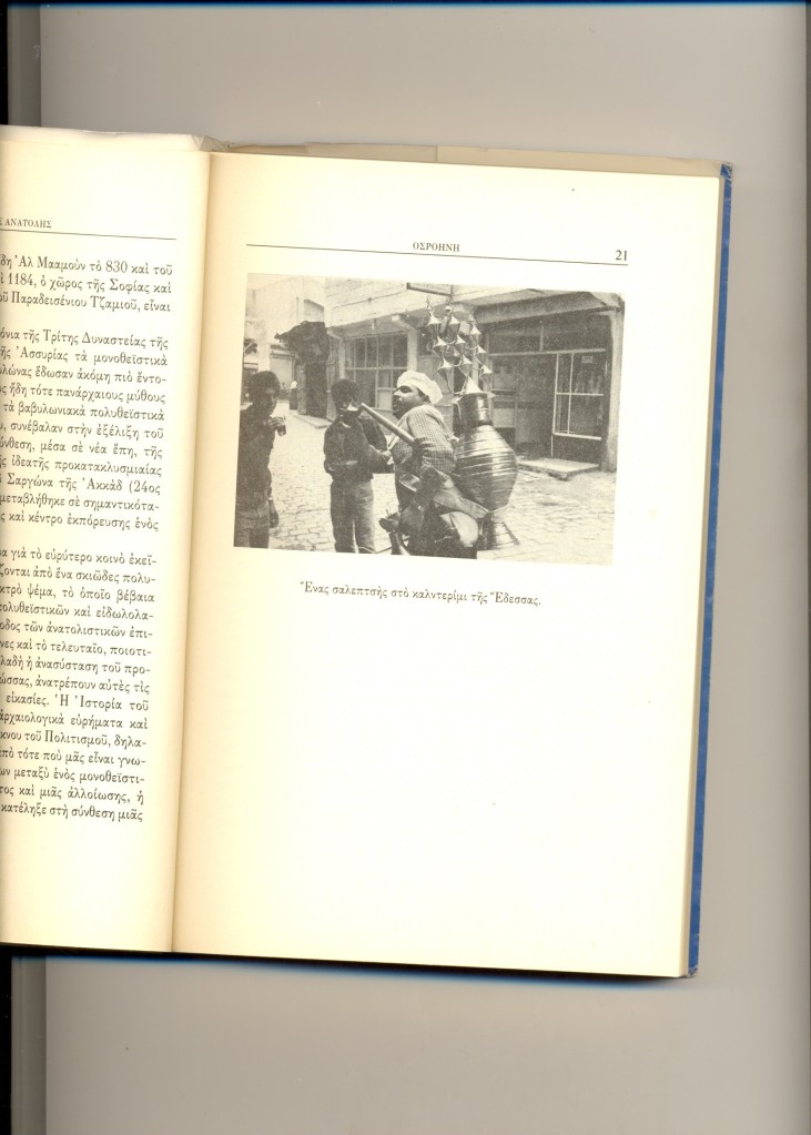
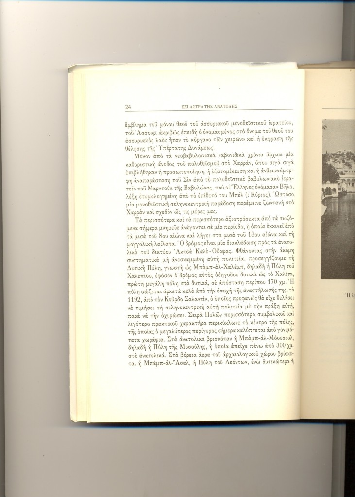
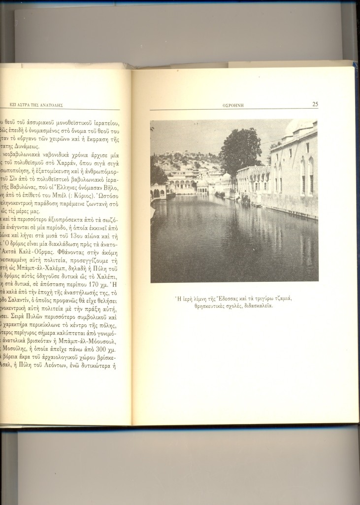
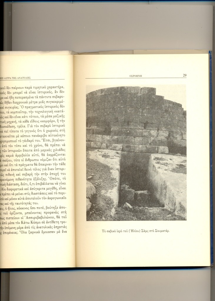
Η Έδεσσα της Οσροηνής (αραμαϊκά: Ουρχόη) είναι σήμερα μια από τις μεγαλύτερες πόλεις και πρωτεύουσες νομού της νοτιοανατολικής Τουρκίας, μόλις 50 χμ από τα συριακά σύνορα και σχεδόν στο μέσον του μήκους τους. Στα τουρκικά λέγεται Ούρφα (Urfa) ή και Σανλί Ούρφα (Şanlıurfa), δηλαδή Ένδοξη Ούρφα, επειδή οι στρατιώτες του Κεμάλ Ατατούρκ την είχαν αποσπάσει από τους επιτιθέμενους Γάλλους αποικιοκράτες.
Δείτε το βίντεο:
Έδεσσα της Οσροηνής (Ούρφα της ΝΑ Τουρκίας): από το Βιβλίο Έξι Άστρα της Ανατολής, του Μουχάμαντ Σαμσαντίν Μεγαλομμάτη
Περισσότερα:
Δεν υπάρχει βιβλίο που να με έχει εντυπωσιάσει περισσότερο από το ιστορικό – θρησκευτικό περιηγητικό του Κοσμά (νυν Μουχάμαντ Σαμσαντίν) Μεγαλομμάτη «Έξι Άστρα της Ανατολής» το οποίο διάβασα πρόσφατα στο Ιντερνέτ. Η μόνη έκδοση του βιβλίου από τις Εκδόσεις Δόμος έχει εξαντληθεί και ο πιο εύκολος τρόπος να διαβάσει κάποιος το εκπληκτικό αυτό έργο είναι να κάνει ένα κλικ εδώ: https://6astratisanatolis.wordpress.com/
Και το πρώτο κεφάλαιο περί Οσροηνής βρίσκεται εδώ:
Δεν νομίζω να υπάρχει στην Ελλάδα ένας, έστω ένας, επιστήμονας ή διπλωμάτης που να γνωρίζει την Τουρκία, την ιστορία της, το παρελθόν και το παρόν της τόσο βαθειά και τεκμηριωμένα όσο ο Μουχάμαντ Σαμσαντίν Μεγαλομμάτης.
Καθώς είχα την τύχη να γνωρίζω κάποιους από τους καλύτερους προσωπικούς του φίλους οι οποίοι πρώτοι μου μίλησαν για το βιβλίο, έχω πρόσφατα επικοινωνήσει μαζί του και του ζήτησα την άδεια να δημοσιεύσω υπό τη μορφή βίντεο επιλεγμένα κομμάτια από το βιβλίο του αυτό, καθώς και τις φωτογραφίες του. Τον ευχαριστώ ιδιαίτερα για τη συγκατάθεσή του.
Το βιβλίο κυκλοφόρησε στις αρχές του 1994 αλλά γράφηκε τμηματικά από το 1989 μέχρι το 1992. Ο Κοσμάς Μεγαλομμάτης είναι επίσης ένας εξαίρετος φωτογράφος και οι φωτογραφίες που δημοσιεύονται στο βιβλίο είναι όλες δικές του. Μετά από μεταπτυχιακή εξειδίκευση σε ασσυριολογία, αιγυπτιολογία, ιρανολογία και ισλαμολογία, ο Κοσμάς Μεγαλομμάτης πέρασε πολλά χρόνια εξερευνώντας και μελετώντας αρχαιότητες και μνημεία σπιθαμή προς σπιθαμή στην Τουρκία, τη Συρία, το Λίβανο, την Παλαιστίνη, την Ιορδανία, το Ιράκ, την Περσία και το Πακιστάν, ενόσω προετοίμαζε τη διδακτορική διατριβή του, από το 1984 μέχρι το 1990. Παράλληλα δημοσίευε άρθρα σε περιοδικά και εφημερίδες σε Ελλάδα, Τουρκία και Περσία, λήμματα σε ελληνικές εγκυκλοπαίδειες, και τα πρώτα του επιστημονικά άρθρα.
Αργότερα, και αφότου έγινε μουσουλμάνος, ο Μουχάμαντ Σαμσαντίν Μεγαλομμάτης εργάστηκε σε τρία πανεπιστήμια στην Τουρκία και την Βόρεια Κύπρο (1994 – 1997) και υπήρξε μέλος κορυφαίων πολιτικών και ακαδημαϊκών θεσμών στην Τουρκία και τη Βόρεια Κύπρο, δημόσια γνωστός χάρη σε τηλεοπτική συμμετοχές και αναφορές σε πρωτοσέλιδα και δελτία ειδήσεων, και συνεργάτης επιφανών πολιτικών της γειτονικής μας χώρας.
Όμως εγκατέλειψε τα πάντα όταν απειλήθηκε επειδή τόσο έγκαιρα αντιλήφθηκε τα αγγλοαμερικανικά σχέδια μερικής και βαθμιαίας ισλαμοποίησης της Άγκυρας, την οποία σαν ιστορικός και πολιτικός επιστήμονας χαρακτηρίζει απλά ως «αποικιοκρατοποίηση» της Τουρκίας.
Θα κλείσω αυτό το εισαγωγικό σημείωμα λέγοντας ότι όπου τελειώνουν η αμορφωσιά (ιδιαίτερα για την Τουρκία και ολόκληρη την Ασία και την Αφρική), η άγνοια, η εθνικιστική και πατριδοκαπηλευόμενη ηλιθιότητα, η φιλοδυτική πολιτική εγληματικότητα και η αντιτουρκική παραφροσύνη του μασωνικού – σιωνιστικού κατεστημένου της χρεωκοπημένης Ελλάδας εκεί αρχίζει η αλήθεια των αναλύσεων και των κειμένων του κ. Μεγαλομμάτη τον οποίο πολλοί πολέμησαν με λύσσα στην Ελλάδα επειδή αποτελούσε κίνδυνο για τα βρώμικα και ελεεινά συμφέροντά τους.
Από το 2001, ο καθ. Μουχάμαντ Σαμσαντίν Μεγαλομμάτης ζει στο Κάϊρο, στο Χαρτούμ, στο Μογκαντίσου, στο Κουργκάν της Σιβηρίας, στο Τουρφάν του Ανατολικού Τουρκεστάν (ΒΔ Κίνα) και σε άλλες χώρες ασιατικές κι αφρικανικές χώρες. Από το 2004 μέχρι σήμερα έχει δημοσιεύσει πάνω από 2000 άρθρα στο Ιντερνέτ. Αυτή την περίοδο, ο κ. Μεγαλομμάτης βρίσκεται στο βόρειο Αφγανιστάν σε εξερευνήσεις μαζί με τους εκεί Χαζάρα και Τατζίκους φίλους του.
Σε επόμενα βίντεο θα παρουσιάσω αποσπάσματα και φωτογραφίες από τα άλλα πέντε (5) κεφάλαια του εξαιρετικού βιβλίου του κ. Μεγαλομμάτη.
Δείτε το βίντεο:
Edessa of Osrhoene (Urfa, SE Turkey): excerpts from Prof. Megalommatis’ The Six Stars of the Orient
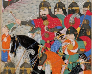
1. Edessa of Osrhoene Edessa of Osrhoene, today’s Urfa in South – Eastern Turkey, is the central point of the first chapter. Already we discover there all the fundamental characteristics and the major trends of Megalommatis’ itinerary narratives. After describing monuments and archeological remains, the author gives a great part of consideration and effort to present – in a very vivid way – several, selected moments of the Edessene past, i.e. various glorious pages of the history of Edessa of Osrhoene, as well as and the entire province of Harran.
The portrait of the rival, Egyptian and Babylonian, armies of Nechao and Nebukadnezzar observing each other from the opposite river shores of Euphrates at Karkhemish is very strong and truly impressive. Certainly, the greater area of Harran was the cross point par excellence between Mesopotamia, Syria, Phoenicia and Anatolia for thousands of years. Megalommatis refers to Harran and its monuments, moving throughout History, from Abraham’s crossing to the Islamic times.
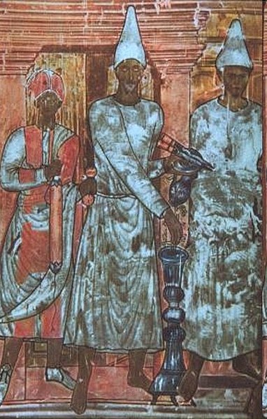
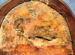
Absolutely fascinating are the descriptions of the Sabians, the famous astrosymbolists of Late Antiquity Sumatar. Muhammad Shamsaddin Megalommatis holds them as highly skillful mysticsinitiated in the greatest secrets pertaining to the End of Time, and to the arrival of the Messiah. The author refers to their voluntary dispersion which was attested several decades ago; he explains the otherwise mysterious development as an indication that the period prophesied as the End of Time has arrived, and he assures his reader that the Sabians, currently unidentified as dispersed in unknown locations, continue pursuing their highly evaluated work during the lifetime of the Messiah. The text turns therefore apocalyptic for the average reader, as the author insinuates that we are living at the times of the Messiah.
(Опубликовано в Афинах в 1994 году профессором Мухаммадом Шамсаддином Мегаломматисом)
1. Эдесса Столица Осроены
Эдесса Столица Осроены, сегодняшняя Урфа в Юго-Восточной Турции, является центральной точкой первой главы. Уже здесь мы обнаруживаем все основные характеристики и основные направления повествований о маршрутах Мегаломматиса. После описания памятников и археологических памятников автор уделяет большое внимание и старается представить – очень живо – несколько избранных моментов прошлого Эдессы, то есть различные славные страницы истории Эдессы и Осроены, а также и вся провинция Харран.
Портрет конкурирующих армий египетского фараона Нечао и вавилонского царя Небукаднеззара, которые наблюдали друг друга с противоположных берегов Евфрата в Кархемиш, очень сильный и поистине впечатляющий. Конечно, большая провинция Харран была точкой пересечения между Месопотамией, Сирией, Финикией и Анатолией – на протяжении многих тысяч лет. Мегаломматис относится к Харрану и его памятникам, которые перемещаются по всей истории от перехода Авраама до исламских времен.
Абсолютно захватывающими являются описания сабиан, знаменитых астросимволистов поздней античности Суматар. Мухаммад Шамсаддин Мегаломматис считает их высококвалифицированными мистиками, посвященными в величайшие тайны, относящиеся к Концу Времени и приходу Мессии. Автор ссылается на их добровольное рассеяние, которое было засвидетельствовано несколько десятилетий назад; он объясняет загадочное развитие, как показатель того, что наступил период, предсказанный как Конец Времени, и заверяет своего читателя, что сабиане, в настоящее время неопознанные и рассеянные в неизвестных местах, продолжают преследовать свою высоко оцененную работу в течение жизни Мессии. Поэтому текст становится апокалиптическим для обычного читателя, поскольку автор намекнул, что мы живем во времена Мессии.
Δείτε το βίντεο:
Эдесса, столица Осроены (Урфа, Юго-Восточная Турция): из книги проф. Мухаммада Шамсаддина Мегаломматиса «Шесть звезд Востока»
(Опубликовано в Афинах в 1994 году профессором Мухаммадом Шамсаддином Мегаломматисом)
1. Эдесса Столица Осроены
Эдесса Столица Осроены, сегодняшняя Урфа в Юго-Восточной Турции, является центральной точкой первой главы. Уже здесь мы обнаруживаем все основные характеристики и основные направления повествований о маршрутах Мегаломматиса. После описания памятников и археологических памятников автор уделяет большое внимание и старается представить – очень живо – несколько избранных моментов прошлого Эдессы, то есть различные славные страницы истории Эдессы и Осроены, а также и вся провинция Харран.
Портрет конкурирующих армий египетского фараона Нечао и вавилонского царя Небукаднеззара, которые наблюдали друг друга с противоположных берегов Евфрата в Кархемиш, очень сильный и поистине впечатляющий. Конечно, большая провинция Харран была точкой пересечения между Месопотамией, Сирией, Финикией и Анатолией – на протяжении многих тысяч лет. Мегаломматис относится к Харрану и его памятникам, которые перемещаются по всей истории от перехода Авраама до исламских времен.
Абсолютно захватывающими являются описания сабиан, знаменитых астросимволистов поздней античности Суматар. Мухаммад Шамсаддин Мегаломматис считает их высококвалифицированными мистиками, посвященными в величайшие тайны, относящиеся к Концу Времени и приходу Мессии. Автор ссылается на их добровольное рассеяние, которое было засвидетельствовано несколько десятилетий назад; он объясняет загадочное развитие, как показатель того, что наступил период, предсказанный как Конец Времени, и заверяет своего читателя, что сабиане, в настоящее время неопознанные и рассеянные в неизвестных местах, продолжают преследовать свою высоко оцененную работу в течение жизни Мессии. Поэтому текст становится апокалиптическим для обычного читателя, поскольку автор намекнул, что мы живем во времена Мессии.
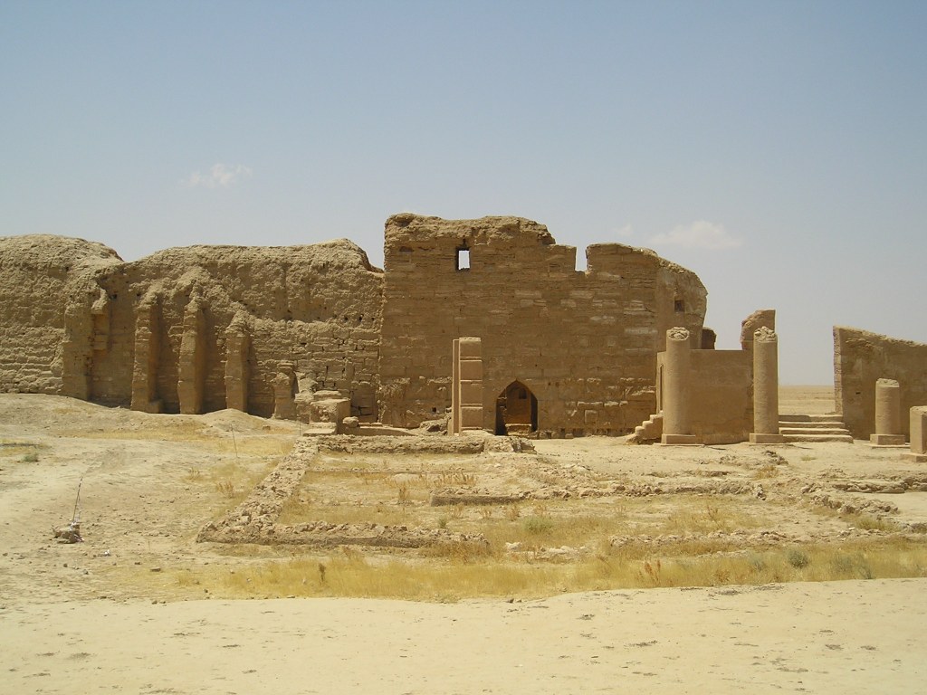
Η Δούρα Ευρωπός (Δοῦρα Εὐρωπός, Dura Europos, Дура Эвропос) είναι ένας από τους σημαντικώτερους αρχαιολογικούς χώρους όλου του κόσμου. Βρίσκεται στα ανατολικά άκρα της Συρίας, ακριβώς πάνω στην αριστερή (δυτική) όχθη του Ευφράτη, λίγο πριν ο ποταμός μπει στο Ιράκ – κάτι που σημαίνει ότι κάνουμε λόγο για τον μέσο ρου του Ευφράτη. Ο αρχαιολογικός χώρος βρίσκεται κοντά στο χωριό Σαλχίγιε, όχι μακριά από την τελευταία μεγάλη πόλη της Ανατολικής Συρίας Αμπού Κεμάλ.
Όπως το όνομά της δηλώνει, η πόλη ήταν αρχικά ένα ασσυροβαβυλωνιακό κάστρο (Ντουρ) στα δυτικά άκρα της Κεντρικής Μεσοποταμίας. Δούρα είναι η εξελληνισμένη μορφή του Ντουρ. Η επιπρόσθετη ελληνική λέξη προσδιορίζει το τεράστιο οπτικό πεδίο που προσφέρει ο παρά τον Ευφράτη λόφος πάνω στον οποίο αρχικά οι Ασσυροβαβυλώνιοι είχαν ανεγείρει ένα φρούριο. Ο χώρος προσφέρει ευρύτατη δυναυτότητα εποπτείας, συνεπώς προσφερόταν για μια σημαντική οχυρωματική θέση.
Στην μακραίωνη ιστορία της η Δούρα Ευρωπός ήταν η πόλη όλων των ορίων: αρχικά ανάμεσα στους Ασσύριους και τους Βαβυλώνιους. Η πόλη είναι το νοτιοδυτικό άκρο της Ασσυρίας και το βορειοδυτικό άκρο της Βαβυλώνας κατά την 2η προχριστιανική χιλιετία. Στα τέλη αυτής της χιλιετίας και στις αρχές της επόμενης, η Ντουρ και ο τριγύρω χώρος κατακλύσθηκαν από τους Αραμαίους που διασπάρθηκαν από τα νότια άκρα της Βαβυλώνας και τις ακτές του Περσικού Κόλπου μέχρι την Δαμασκό, την Κιλικία ή ακόμη την Λυδία όπως τεκμηριώνουν δίγλωσσες λυδικές – αραμαϊκές επιγραφές που έχουν σωθεί.
Ωστόσο, σήμερα, η Δούρα Ευρωπός δεν είναι αντικείμενο έρευνας των Ασσυριολόγων. Ο χώρος, του οποίου η ακμή ανάγεται στα σελευκιδικά, αρσακιδικά, και ρωμαϊκά χρόνια, είναι αντικείμενο έρευνας πολλών και διαφορετικών επιστημόνων. Η ανεύρεση αραμαϊκών, ελληνικών, λατινικών, παρθικών και περσικών επιγραφών ελκύει το ενδιαφέρον σημιτολόγων, ελληνιστών, λατινιστών και ιρανολόγων. Η τεράστια σημασία της καραβανούπολης ως κομβικού σημείου στους Ιστορικούς Δρόμους του Μεταξιού, των Μπαχαρικών και των Λιβανωτών την καθιστά αντικείμενο έρευνας όλων των ειδικών του Ρωμαϊκού Εμπορίου με την Κίνα.
OLYMPUS DIGITAL CAMERA
Όμως περισσότερο από τα προαναφερμένα, η ιστορική
σημασία της Δούρας Ευρωπού είναι ένα κάλεσμα για τους ιστορικούς θρησκειών,
τους θρησκειολόγους που ειδικεύονται
1- στον Μιθραϊσμό και ιδιαίτερα στην αποδοχή του
ανάμεσα στους Αραμαίους,
2- στην διάδοση ανατολικών θρησκειών, λατρειών,
μυθολογιών, θεουργιών, μυστικισμών και επιστημών στην Ρωμαϊκή Αυτοκρατορία και
την Μεσόγειο,
3- στον Ιουδαϊσμό και την διάδοση της αρχαίας
ιουδαϊκής θρησκείας ανάμεσα στους Αραμαίους (που χαρακτηριστικά εκπροσωπεί η
γνωστή Σαμαρείτιδα των ευαγγελικών περικοπών),
4- στην διατήρηση αρχαιοελληνικών και ρωμαϊκών
θρησκειών και λατρειών ανάμεσα στις ελληνικές και ρωμαϊκές κοινότητες του
σελευκιδικού και ρωμαϊκού κόσμου, και
5- στην διαμόφωση συγκρητικών μορφών θρησκειών με την
ανάμειξη στοιχείων πολλών, διαφορετικής προέλευσης, δογμάτων.
Οι χρόνοι της ακμής της Δούρας Ευρωπού τοποθετούνται στην
περίοδο από το 303 π.Χ., όταν ο Σέλευκος Νικάτωρ ανήγειρε εκνέου την πόλη ως
κεντρικό σημείο στον δρόμο που συνέδεε την Αντιόχεια με την Σελεύκεια επί του
Τίγρη (νότια της σημερινής Βαγδάτης), μέχρι την ιρανική σασανιδική επίθεση και
καταστροφή της πόλης το 256 μ.Χ., όταν ο Σαπούρ Α’ μετώκισε το σύνολο του
πληθυσμού στα ανατολικά κι άφησε την πόλη ως ερείπια να χαθεί κάτω από την άμμο
της ερήμου για σχεδόν 1700 χρόνια.
Τα πολλά ευρήματα, τα τείχη, οι πύργοι, τα τεράστια κτήρια,
οι πολλοί ναοί, το Μιθραίο, η Εκκλησία, η Συναγωγή, εντυπωσιακές τοιχογραφίες,
οι πολλές επιγραφές και τα λοιπά κειμενικά τεκμήρια (περγαμηνές) που
ανασκάφηκαν, ανασκάπτονται και θα ανασκαφούν στην Δούρα Ευρωπό κάνουν τον τόπο
αυτό ένα από τα μοναδικά στην Παγκόσμια Ιστορία δείγματα αυθεντικής
πολυπολιτισμικής κοινωνίας, η οποία αναπτύχθηκε από την εθελούσια συνεργασία
και συμβίωση πολλών διαφορετικών εθνών, κι όχι από τυχον παράξενη υποκίνηση,
τεχνητή υποδαύλιση, και υστερόβουλη επέμβαση. Ήταν μια φυσιολογική συνέπεια των
γενικωτέρων εξελίξεων στον ευρύτερο χώρο κι όχι ένα προγραμματισμένο και
προσχεδιασμένο τερατούργημα.
Στην Δούρα Ευρωπό ομιλήθηκαν διάφορες αραμαϊκές
γλώσσες και διάλεκτοι, καθώς υπήρχαν ντόπιοι Αραμαίοι αλλά και Παλμυρηνοί και
Χατραίοι (: από την Χάτρα, άλλη αραμαϊκή καραβανούπολη – κέντρο εμπορίου Δύσης –
Ανατολής, στο σημερινό βορειοδυτικό Ιράκ). Επίσης ομιλήθηκαν αρχαία ελληνικά,
λατινικά, παρθικά, ιουδαϊκά, μέσα περσικά, αρχαία υεμενικά, και αραβικά, καθώς
από κει περνούσε το εμπόριο από την Μεσόγειο προς το Ιράν, την Ινδία και την
Κεντρική Ασία, όπως επίσης και το εμπόριο από την Υεμένη και το Κέρας της
Αφρικής προς τον Καύκασο και περιοχές της Κεντρικής Ασίας.
Η Ιστορία της Δούρας Ευρωπού τεκμηριώνει κάτι το πολύ
σημαντικό: δεν χρειάζεται μια πόλη για να μείνει ως εξαιρετικά σημαντική στην
Ιστορία να είναι πρωτεύουσα ενός ισχυρού κράτους. Κι έτσι ήταν η ιστορία αυτού
του μοναδικού τύπου που λειτούργησε σαν χωνευτήρι πίστεων, παραδόσεων, δοξασιών
και μυστικισμών σε βαθμό που την αποκάλεσαν Πομπηία της Ερήμου.
Η Δούρα Ευρωπός παρέμεινε σελευκιδική από το 303 π.Χ.
μέχρι το 113 π.Χ. όταν την κατέκτησαν οι Πάρθοι, οι οποίοι την εκράτησαν μέχρι
το 114 μ.Χ., όταν επελαύνοντας προς τα ανατολικά την κατέλαβε ο Τραϊανός, ο μόνος
Ρωμαίος αυτοκράτορας που έφθασε στον μυχό του Περσικού Κόλπου και στα δυτικά
παράλια της Κασπίας. Οι Πάρθοι ανακατέλαβαν την πόλη το 117 μ.Χ. και την
διατήρησαν μέχρι το 165 μ.Χ. Τότε οι Ρωμαίοι την ανέκτησαν και την διατήρησαν,
ως ‘Αποικία’ (Colonia) από το 211 μ.Χ., μέχρι την
σασανιδική ιρανική κατάληψη του 256 μ.Χ. και καταστροφή της πόλης.
Έτσι, η Δούρα Ευρωπός υπήρχε πάντοτε μια πόλη ανάμεσα
σε δυο κόσμους: του Σελευκίδες της Συρίας και τους Αρσακίδες του Ιράν πρώτα,
και τους Ρωμαίους και τους Σασανίδες του Ιράν έπειτα. Με τους Ρωμαίους και
Μακεδόνες κατοίκους της, η Δούρα Ευρωπός παρέμεινε το ανατολικώτερο σημείο όπου
αρχαία ελληνικά και λατινικά ομιλούντο τον 3ο αιώνα στην Συρο-Μεσοποταμία.
Για την Δούρα Ευρωπό μπορούν να γραφούν
εγκυκλοπαίδειες. Είναι ο χώρος όπου σώζονται η αρχαιότερη εκκλησία, η
αρχαιότερη συναγωγή και το αρχαιότερο Μιθραίο δυτικά του Ιράν.
Δείτε το βίντεο:
Дура Эвропос: Многокультурный караванный город на
берегу Евфрата: арамейцы, греки, римляне и иранцы
Первоначально на месте Д.-Е. располагалась
древнеассир. крепость. В 300-280 гг. до Р. Х. Селевк I Никатор основал там
колонию македон. воинов, охранявших переправы через Евфрат на пути из 2 столиц
гос-ва Селевкидов – Антиохии-на-Оронте и Селевкии-на-Тигре. Приблизительно
после 113 г. до Р. Х. в составе Месопотамии Д.-Е. перешел под власть Парфии,
став важным форпостом в Сирии. Население города к I в. до Р. Х. было по
преимуществу арамейским. В 116 г. Д.-Е. был оккупирован войсками рим. имп.
Траяна, позже возвращен имп. Адрианом парфянам, в 165 г., во время парфянского
похода имп. Луция Вера, завоеван римлянами и включен в состав рим. пров. Сирия,
в 211 г. получил статус колонии. С рим. завоеванием Д.-Е. стал одним из
форпостов в войнах с Парфией, его гарнизон был увеличен за счет войск, базировавшихся
в Сев. Европе, было начато строительство оборонительных сооружений. С падением
Парфии и усилением гос-ва Сасанидов город неоднократно переходил из рук в руки.
В 256 или 257 г. крепость была разрушена войсками сасанидского царя Шапура I
(сохр. следы разрушений, останки воинов, погибших в подстенных подкопах). В
260-273 гг. Д.-Е. входил в состав гос-ва Пальмира, позже стал местом поселений
христ. отшельников, постепенно был поглощен пустыней.
В эпоху правления Селевкидов (возможно, раньше) город
был окружен зубчатой стеной со сторожевыми башнями (сохр. остатки 26), разделен
улицами на квадраты по античной Гипподамовой системе (судя по следам
неоконченных строительных работ, первоначальный план не был осуществлен;
основной план сохр. структуру эллинистического города). От главных Пальмирских
ворот (17-16 гг. до Р. Х.) начиналась широкая улица, на к-рой находилась агора;
по оси этой улицы в юго-вост. части города располагалась старая цитадель,
основанная греками как стратегион (резиденция стратега), на северо-востоке –
новая цитадель (времени Селевкидов, II в. до Р. Х.; перестроена и достроена в
парфянский период), у сев. оконечности города, у приречной стены,- резиденция
начальника рим. гарнизона (после 227).
От парфянского времени в Д.-Е. сохранились руины
цитадели и дворца, остатки жилых домов, руины храмов греч., местных вост. и
синкретических греко-сир. и греко-иран. божеств: Баала-Бела, Артемиды, культ
к-рой слился с культом иран. Нанайи (40-33 гг. до Р. Х., перестроен при
парфянах из греч. храма, служил центром офиц. культа Д.-Е. в греч., парфянский
и рим. периоды), сир. богини Атаргатис (31-2 гг. до Р. Х., к востоку от храма
Артемиды-Нанайи, построен по сходному плану), Зевса Кириоса (Господа), Зевса
Теоса (Бога) (114 г., к северу от кардо), Зевса Мегиста (Величайшего) (169 г.,
на месте древнего храма 95-70 гг. до Р. Х., имеет смешанные греко-парфянские
черты), т. н. храма Пальмирских богов, или храма Гадде, посвященного 2
пальмирским божествам – Баалам (до 159, между храмом Атаргатис и агорой Д.-Е.),
Адониса и др. Нек-рые из храмов были расписаны, в руинах обнаружены рельефы и
статуи. К рим. времени относятся укрепления в военном квартале и возведенные на
месте жилого квартала парфянского времени строения, предназначенные для
гарнизона, занявшие 1/4 территории города, где располагались термы и храмы. В
храмах Д.-Е. обнаружено множество вотивных рельефов, стилистически близких к
пальмирским, при полном их отсутствии в погребальных комплексах.
Открытые в Д.-Е. жилые дома (по типу и архитектурному
декору греч. или эллинизированные, рим. или отмеченные рим. влиянием – «дворец
Лисия» с портиком на стороне террасы, обращенной к Евфрату; «дворец начальника
пограничной стражи» в военном квартале) и многочисленные святилища имеют
месопотамский облик – комплекс помещений вокруг главного двора, окруженного
стеной. За стенами Д.-Е. расположены некрополи, представляющие собой подземные
захоронения с неск. погребальными башнями.
В 256 г., видимо незадолго до осады армией Сасанидов,
застроенный квартал шириной ок. 12-15 м, прилежащий к стене, высота к-рой
составляла 10 м, был засыпан рим. солдатами битым кирпичом, благодаря чему до
наст. времени сохранились храм Пальмирских богов, митреум (храм Митры), дом
рим. типа с «домовой церковью», синагога (с 245).
Остатки крепости Д.-Е. были обнаружены 30 марта 1920
г., когда при рытье траншей брит. солдаты увидели росписи храма Пальмирских
богов с изображением жрецов и римского легионера, приносящих жертвы богам.
Эксперт археолог Дж. Г. Брестед, 1-м ознакомившийся с городищем, предположил,
что оно известно по лит. источникам как Д.-Е. В 1922-1923 гг. раскопки Д.-Е.
вела франц. экспедиция под рук. Ф. Кюмона (в публикации 1926 г. он подтвердил,
что обнаруженный город является Д.-Е.), в 1928-1937 гг.- франко-амер.
экспедиция под рук. М. И. Ростовцева из Йельского ун-та; раскопки были
остановлены в связи с началом второй мировой войны. В сер. 80-х гг. раскопки
возобновлены франко-сирийской экспедицией под рук. П. Лериша.
Ду́ра-Е́вропос [греч. Ϫοῦρα Εὔρωπος], древний город на берегу р. Евфрат, у одной из главных дорог,
связывавших Дамаск с Месопотамией; в наст. время – городище близ дер.
Эс-Салихия (Вост. Сирия); музей под открытым небом. Совр. название условно и
образовано из слияния арам. duru – стена, крепость (название бытовало среди
местного населения) и македон. топонима Europos (офиц. название в греко-рим.
документах).
Памятники материальной культуры и эпиграфики,
сохранившиеся в Д.-Е., доказывают, что в парфянский период его население было
сирийским, арабским и иранским. Этническая картина усложнилась при Селевкидах с
поселением греков и македонян, затем – с рим. завоеванием. Различные религии
были принесены в Д.-Е. греками, рим. воинами (в основном германцами из Сев.
Европы), арабами из Пальмирского оазиса, степными кочевниками, парфянами;
население разделялось по вероисповеданию, о чем свидетельствуют надписи: в
синагоге они выполнены на арам. языке, в «церкви» – на греческом.
Dura Europos
(“Fort Europos”) is a ruined Hellenistic-Roman walled city built on
cliff 90 meters above the banks of the Euphrates river. It is located near the
village of Salhiyé, in today’s Syria. Destroyed by war and abandoned in the 3rd
century AD, it lie hidden until its rediscovery in 1920. Excavations have
revealed, among other important ruins, the oldest synaogogue and oldest church
ever found. Due to its remarkable preservation and has sometimes been dubbed
the “Pompeii of the Syrian Desert.”
Dura Europos
was founded in 303 BC by the Seleucids (Alexander the Great’s successors) on
the intersection of an east-west trade route and a north-south trade route
along the Euphrates. The new city, named for the birthplace of Seleucus I
Nicator, controlled the river crossing on the route between Antioch on the
Orontes and Seleucia on the Tigris. Dura Europos was part of a network of
military colonies intended to secure Seleucid control of the Middle Euphrates.
Dura was
rebuilt as a great Hellenistic city in the 2nd century BC, with a rectangular
grid of streets arranged around a large central agora, was formally laid out.
Its location on a major crossroads made it a very cosmopolitan city:
inscriptions in many languages have been found here and the religious buildings
of pagans, Jews and Christians stand side by side.
Dura Europos
later became a frontier fortress of the Parthian Empire and it was captured by
the Romans in 165 AD. In the early 200s AD, the famed house-church and
synagogue were built at Dura Europos. There was also a Mithraeum, a Temple of
Bel and a Temple of Adonis in the multi-cultural city.
Dura Europos
was abandoned after a Sassanian siege in 256-257. In a last-ditch attempt to
save the city, the synagogue was filled in to make a fortress, thereby ensuring
its preservation. The city eventually became covered in shifting sands and
disappeared from sight.
Although the
existence of Dura-Europos was long known through literary sources, it was not
rediscovered until British troops under Captain Murphy made the first discovery
during the Arab rebellion in the aftermath of World War I. On March 30, 1920, a
soldier digging a trench uncovered beautifully preserved frescoes. The American
archeologist James Henry Breasted, then at Baghdad, was alerted. Major
excavations were carried out in the 1920s and 1930s by French and American
teams.
The first
excavations of the site, undertaken by Franz Cumont and published in 1922-23,
identified the site as Dura-Europos and uncovered a temple before renewed
hostilities in the area closed it to archaeology. Later, renewed campaigns
directed by Michael Rostovtzeff funded by Yale University continued until 1937,
when funds ran out with only part of the excavations published. World War II
then interfered.
Since 1986
excavations have resumed. Not the least of the finds were astonishingly
well-preserved arms and armour belonging to the Roman garrison at the time of
the final Sassanian siege of 256. Finds included painted wooden shields and
complete horse armours, preserved by the very finality of the destruction of
the city that journalists have called “the Pompeii of the desert”.
The largely
mud-brick architecture of Dura Europos does not compare to Palmyra visually,
but the dramatic remains of the walls and siegeworks combined with precipitous
views over the green valley of the Euphrates makes for a striking sight. And
arguably, Dura surpasses Palmyra in historical and religious importance.
Dura-Europos
was a cosmopolitan society: over a hundred parchment and papyrus fragments and
many inscriptions have been discovered at the site, which include Greek, Latin,
Palmyrenean, Hebrew, Hatrian, Safaitic, and Pahlavi.
Three of the
covered homes in Dura Europos had been converted for use as religious
buildings. One had become a Mithraeum, dedicated to the worship of the god
Mithras, who was popular with Roman soldiers. Another had undergone structural
modifications to become a Jewish synagogue. The third home had been converted
to a Christian church. The synagogue and church are the oldest that have been
found anywhere, and are also remarkable in that they were built very close to
each other at virtually the same time.
The world’s
oldest preserved Jewish synagogue in Dura-Europos has been dated by an Aramaic
inscription to 244. It was preserved when it was filled with earth to
strengthen the city’s fortifications against a Sassanian assault in 256. It was
uncovered in 1935 by Clark Hopkins, who found that it contains a forecourt and
house of assembly with frescoed walls depicting people and animals, and a Torah
shrine in the western wall facing Jerusalem.
The
synagogue’s painted walls and roof of baked-brick tiles were transported across
the desert 300 miles away to Damascus, where it became the centrepiece of the
National Museum built in 1934. Yale had to settle for a copy.
Dura-Europos
also boasts the oldest known Christian church. It was dismantled and
re-constructed at Yale University in the early 1930s, so there isn’t much to
see at Dura-Europos but basic foundations.
The church
occupied a typical Roman upper-class house centered around a columned courtyard
with an open room (atrium). In the center of the courtyard was a pool
(impluvium). At the opposite end from the entrance was a raised area (tablinum)
containing a table and used by the family as a reception area and for
ceremonial functions.
Scholars
speculate that the congregation gathered around the pool, which was used for
baptism. In the tablinum sat the bishop, who celebrated the Eucharist
(communion) at the table. This arrangement provides a basis for the liturgical
arrangement of later basilica churches.
The murals
of the Dura Europos chuch were painted between 232 and 256 AD and are among the
earliest examples of Christian art that survives today. The mural of the
Healing of the Paralytic contains the earliest image of Jesus found anywhere.
In 1933, an
important fragmentary text was unearthed at Dura Europos that contained a
previously unknown Greek harmony of the gospels, dated to the late 2nd century.
This has been important for early Christian studies, particular those of Tatian’s
Diatessaron, a more well-known gospel harmony.
Excavations
have also revealed the ruins of pagan temples dedicated to Greek, Roman and
Palmyrene gods, including a Temple of Bel (a Semitic god) and a Temple of
Adonis (a Greek god).
Preserved in
the Temple of Adonis was a 2nd-century dedicatory inscription, which is now in
the Louvre Museum. Other finds from Dura can be seen at the National Museum in
Damascus and elsewhere.
Δούρα Ευρωπός: Το Μέγιστο Πολυπολιτισμικό Κέντρο της Ιστορίας – Αραμαίοι, Έλληνες, Ρωμαίοι, Ιρανοί
Περισσότερα:
Η Δούρα Ευρωπός είναι αρχαία πόλη, στις όχθες του
ποταμού Ευφράτη, στα σύνορα μεταξύ Μεσοποταμίας και Συρίας. Ιδρύθηκε, ως
στρατιωτική αποικία, μετά το πέρας του Βαβυλωνιακού πολέμου (311-309 π.Χ.) από
τον στρατηγό Νικάνορα (λογικά είναι το ίδιο πρόσωπο που ίδρυσε την Έδεσσα και
την Αντιόχεια Μυγδονική) για λογαριασμό του κυρίου του Σελεύκου Α΄ Νικάτορος
(358-281 π.Χ.), ενός εκ των βασιλικών φίλων του Μεγάλου Αλεξάνδρου. Η ονομασία
Ευρωπός προέρχεται από την ομώνυμη πατρίδα του Σελεύκου στην Μακεδονία.
Το 253 ή 256 μ.Χ. καταστράφηκε από τους Πέρσες και
σκεπάστηκε από την άμμο. Όταν, στις δεκαετίες 1920 – 1930, η αρχαιολογική
σκαπάνη την επανέφερε στο φως ο Mikhail Rostovtzeff την είχε αποκαλέσει
«Πομπηία της ερήμου». Η ανακάλυψή της έγινε τυχαία από το βρετανικά στρατεύματα
το 1920.
Dura-Europos
(Greek: Δοῦρα Εὐρωπός), also spelled Dura-Europus, was a Hellenistic, Parthian and Roman
border city built on an escarpment 90 metres (300 feet) above the right bank of
the Euphrates river. It is located near the village of Salhiyé, in today’s
Syria. In 113 BC, Parthians conquered the city, and held it, with one brief
Roman intermission (114 AD), until 165 AD. Under Parthian rule, it became an
important provincial administrative center. The Romans decisively captured
Dura-Europos in 165 AD and greatly enlarged it as their easternmost stronghold
in Mesopotamia, until it was captured by the Sasanian Empire after a siege in
256–57 AD. Its population was deported, and after it was abandoned, it was
covered by sand and mud and disappeared from sight.
Dura-Europos
is extremely important for archaeological reasons. As it was abandoned after
its conquest in 256–57 AD, nothing was built over it and no later building
programs obscured the architectonic features of the ancient city. Its location
on the edge of empires made for a co-mingling of cultural traditions, much of
which was preserved under the city’s ruins. Some remarkable finds have been
brought to light, including numerous temples, wall decorations, inscriptions,
military equipment, tombs, and even dramatic evidence of the Sassanian siege.
Ду́ра-Эвропо́с (греч. Δοῦρα Εὐρωπός) — античный город на Евфрате
(вблизи современного города Сальхиях в Сирии), существовавший примерно с 300
года до н. э. до 256 года. Получил известность в связи с археологическими
находками и хорошо сохранившимися древними фресками. Дура на арамейском
означает «крепость».
Город был основан царём Селевком I Никатором около 300 года до н.
э. среди многих других и просуществовал более 550 лет. Примерно в 100 году до
н. э. перешёл под власть Парфянского царства, а с 165 года — Римской империи. В
римское время Дура-Европос был крупным торговым центром, и большинство
археологических находок относятся к этому периоду времени. В 256 году захвачен
войсками Сасанидов и заброшен.
Селевк, диадох Александра Македонского, выбрал для
поселения своих солдат заброшенную ассирийскую крепость на дороге из Дамаска в
Междуречье и дал ей имя «Дура». Римляне назвали город «Дура-Европос», потому
что местная аристократия состояла из потомков македонцев, то есть они
подчеркнули что город управляется «европейцами» из Македонии. Крепость стояла
на высоком берегу среднего Евфрата, защищённая с трёх сторон крутыми обрывами,
а четвёртая сторона, противоположная от реки и примыкающая к пустыне, была
обнесена длинной прямой стеной с башнями. Размеры города составляют примерно
700 на 1000 м.
Город регулярно спланирован (прямо пересекающиеся
улицы) в селевкидское время, к которому относятся агора, остатки храмов,
цитадель. Со временем гражданское население стало превалировать, и крепость
превратилась в захолустный городок, выросший вокруг рыночной площади. Однако
население можно назвать гражданским лишь условно. В военное время земледельцы
вставали в строй, образуя сословие так называемых клерухов. В социальном отношении
жители делились по родам, как и в Македонии. Земля клерухам давалась в
пожизненную аренду за их службу или службу их детей, оставаясь царской
собственностью.
Dura Europos,
ruined city on the right bank of the Euphrates between Antioch and Seleucia on
the Tigris, founded in 303 B.C.E. by Nicanor, a general of Seleucus I. It
flourished under Parthian rule. The site is in modern Syria, on a plateau
protected on the east by a citadel built on bluffs overlooking the river, on
the north and south by wadis, and on the west by a strong rampart with powerful
defensive towers. Its military function of the Greek period was abandoned under
the Parthians, but at that time it was the administrative and economic center
of the plain extending 100 km between the confluence of the Ḵābūr and
Euphrates rivers and the Abū Kamāl gorge to the south.
I. Archaeology
and History
Initial
archeological exploration of the city took place in 1920-22, under the direction
of Franz Cumont and the sponsorship of the Académie des Inscriptions et
Belles-Lettres in Paris. From 1929 to 1937 Yale University and the Académie
sponsored excavations under the initiative of M. I. Rostovtzeff, who published
Dura-Europos and Its Art, a synthesis of the history of the town and of its
civilization, formed from Greek, Semitic, and Iranian components. This work has
served as the basis for all subsequent studies of the site. In fact, however,
understanding of Dura Europos depended mainly on written materials (parchments,
papyri, inscriptions, and grafitti; see ii, below), paintings, tombs, and
portable objects (e.g., coins, bronzes, and lamps) from the excavations, and
very little attention has been paid to the architectural remains. Although
nearly a third of the town has been excavated, a large number of buildings have
been published only summarily or not at all. It therefore became necessary to
resume the work of publication, and for this reason the Mission Franco-Syrienne
de Doura-Europos was formed in 1986 under the joint direction of the author and
Assad Al-Mahmoud; the major objectives are to reexamine the archeological data,
to make available the entire mass of documentation from previous excavations,
as well as to save the monuments from destruction.
Dura Europos
was brought into the Iranian cultural sphere after the Parthian conquest in
about 113 B.C.E. (Bellinger; Welles). This domination lasted three centuries,
interrupted by a Roman occupation in 115-17 C.E., during Trajan’s expedition to
Ctesiphon. In 165 Dura was conquered by Avidius Cassius and became a stronghold
in the Roman defensive system along the eastern frontier of the empire.
Nevertheless, despite an impressive effort to reinforce its defenses, the town
was unable to withstand the great offensive launched by the Sasanian Šāpūr I
(240-70) in 256; it was taken after a bitter siege, and the population was deported,
thus putting an end to the town’s existence.
The Parthian
period
According to
recent discoveries, Dura Europos, originally a fortress, was constituted as a
city only in the late Hellenistic period and had been only sparsely populated
throughout the Greek period. It was under the Parthians, however, that the city
assumed its essential aspect, as revealed by the excavations, a configuration
only partly modified by the Roman occupation, except for transformation of the
northern sector into a Roman camp. Recent work by the Mission Franco-Syrienne
has permitted some refinement of this picture; certain buildings that had
formerly been attributed to the Parthians can now be dated to the Hellenistic
period. For example, according to Armin von Gerkan, the cut-stone
fortifications of Dura Europos had been built by the Parthians, fearful that
the Greek wall of unbaked bricks would be insufficient against a Roman attack.
Only the northern section of the original western wall survived, which he took
as proof that the project had been rendered unnecessary by the peace concluded
between the Parthians and Augustus in 20 B.C.E. (pp. 4-51). This conclusion was
based more on probabilities extrapolated from the reports of ancient historians
than on archeological discoveries and has been contradicted by the results of
recent soundings and clearing of earlier trenches. It is now clear that it was
the Greeks themselves who built the stone fortifications, in the second half of
the 2nd century B.C.E., and that the use of mud bricks resulted from the
imminent threat from the Parthians, which forced the builders to finish the
wall with more easily obtained material (Leriche and Mahmoud, l990). Similarly,
the reconstruction of the palace of the strategus and its extension to the
north, as well as construction of the second palace in the citadel, which shows
a number of similarities, had been attributed to the Parthian period, but
recent excavations in the interior and at the base of the facade of the former
building have revealed that it belongs to the 2nd century B.C.E., that is, the
Greek period. In a recent study Susan Downey (1988) has also called into
question the restoration of one palace with an ayvān, which was suggested in
the Yale publications and would imply a Parthian construction.
The Parthian
period thus appears to have been primarily a phase of expansion at Dura
Europos, an expansion favored by abandonment of the town’s military function.
All the space enclosed by the walls gradually became occupied, and the
installation of new inhabitants with Semitic and Iranian names alongside
descendants of the original Macedonian colonists contributed to an increase in
the population (Welles et al.). In his celebrated Caravan Cities Rostovtzeff
had argued that this prosperity could have resulted from the town’s position as
a trading center and caravan halt, but this hypothesis has been abandoned, for
nothing uncovered by the excavations has confirmed it. Instead, Dura Europos
owed its development to its role as a regional capital, amply illustrated by
the contents of inscriptions, parchments, and papyri.
In the
Parthian period Greek institutions remained in place (Arnaud), and the
property-zoning scheme established in the Hellenistic period was respected in
new construction; that is, buildings were kept within the limits of
pre-existing blocks 35 x 70 m laid out uniformly over the entire surface of the
plateau, even to a large extent in the interior wadis. The only exceptions were
the quarter of the town southeast of the citadel, which had apparently already
been occupied before the division into lots, and a sector of the agora that had
been invaded by domestic buildings. The ramparts were neglected: Domestic trash
accumulated along the periphery, finally forming a mass so thick that it
prevented access to certain towers on the western wall.
The
architecture of the Parthian period was characterized by a progressive
evolution of Greek concepts toward new formulas in which regional traditions,
particularly those derived from Babylonia, played an increasing role. These innovations
affected both religious and domestic buildings. No secular public building is
known to have been built during the Parthian period, with the possible
exception of a bath constructed of cut stone in the northeast sector of the
town. The evolved Parthian forms generally persisted into the Roman period,
except for buildings in the Roman camp in the northern third of the town, for
example, the palace of the Dux Ripae and the praetorium.
The
architecture of private dwellings varied in detail according to the wealth of
the owner. The systematic layout of the Greek city, in which each house was
supposed to cover one-eighth of a block (ca. 300 m2), was abandoned or modified
through subdivision and consolidation resulting from sales or inheritance
(Saliou). The smallest houses covered one quarter or even less of a Greek lot,
whereas other, more luxurious examples might cover up to half a block. But the
organizing principle of the house remained fundamentally the same: The street
door, often situated at a corner of the house, opened onto a corridor leading
into a central courtyard, which provided access and light to the various rooms
of the house. The principal room, the andrón, was usually situated on the south
side, opening to the north, and was surrounded on all four walls by a masonry
bench; it served as a reception room (Allara). Some houses incorporated
columns, but gabled roofs disappeared in favor of terraces, rooms became
irregular in shape, and several houses had second stories.
Religious
architecture underwent a comparable evolution, traceable through numerous
excavated buildings: the temples of Artemis Nanaïa II and Zeus Megistos II, the
necropolis temple, and the temples of Artemis Azzanathkona, Zeus Kyrios,
Atargatis, Bel, Aphlad, Zeus Theos, Gad, and Adonis. This architecture diverged
more and more from the hypothetical Greek model, if in fact such a model had
ever been introduced at Dura Europos (Downey, 1988, p. 176). All the temples of
the Parthian period have the same basic plan, with variations in detail. A
generally square temenos is enclosed by a blank wall; the naos stands at the
back of the interior courtyard facing the entrance. Against the interior face
of the enclosure wall are a series of rooms for service or secondary cults,
usually built by donors. When the naos is set against the back wall of the
temenos, a narrow space is left between them to provide a separation of the
cella from the exterior world. The building is small, usually square in plan,
and raised on a podium of two or three steps, with one or more altars in front.
The interior is divided in two: the pronaos, which occupies the full width of
the building and is sometimes furnished with tiers of benches on either side of
the entrance, and the cella, usually flanked by two chapels or lateral
sacristies. The cult image on the wall opposite the entrance, either mounted on
a pedestal or painted directly on the surface. All that remains from the Greek
tradition is the occasional presence of a columned facade in front of the
temple or porticoes along the sides of the courtyard, as at the temple of Bel.
It is thus
clear that at Dura Europos entirely original architectural formulas were
perfected during the Parthian period, in both religious and domestic
constructions; the Babylonian element predominated, though with a certain Greek
dressing, but no unequivocal Iranian influence appears. The formula for
religious buildings was followed in all temples, whatever the form of worship
to which they were consecrated, Greek or Semitic.
The only
Iranian cult known at Dura Europos was that of Mithra, which paradoxically had
been introduced into the city by Roman troops in 168. The mithraeum, located
near the western wall in the Roman camp, belongs to the type dedicated to the
cult throughout the Roman world and has no features in common with the other
religious buildings at Dura Europos, except that it stands on a podium. It
appears to have been a single room of modest dimensions with a bench on each of
the longer sides; above the central aisle there was a raised ceiling with a
clerestory. At the end of the room was a niche containing two cultic
bas-reliefs with an altar before them. The entire surface of the room was
covered with painted decoration: scenes from the life of Mithra,
representations of magi and the zodiac around the bas-reliefs in the niche, and
mounted hunting scenes on the side walls.
Although
Iranian influence is difficult to find in the architecture of Dura Europos, in
figurative art it is much more pronounced. In fact, owing to landfill that
preserved religious buildings along the western wall (see below), Dura has
provided the main evidence of a decorative art that seems to have developed in
Parthian domains, reflecting a synthesis of the traditions of the ancient Near
East (linear drawing, two-dimensional forms, stiff poses) and the Hellenic
world (the use of architectural decoration and friezes, types of dress). Furthermore,
in religious settings, those most fully represented, the principle of “Parthian
frontality” prevailed. This convention, according to which all figures, human
or divine, face directly forward, with eyes fixed on the spectator, made its
appearance at Dura very early, in the oldest painting, of the sacrifice of
Conon, in the temple of Bel (probably 1st century C.E.). It persisted until the
destruction of the city, as attested in the frescoes of the synagogue, dating
from 245. It was equally apparent in sculpture and terra-cottas (except for a
statue of Artemis with the tortoise, which comes from a Hellenistic center)
and, for example, in two reliefs of the Gads of Dura and Palmyra. On the other
hand, in frequent narrative scenes of combat and hunting on horseback, like
those in the mithraeum, the horses and wild beasts are portrayed in a flying
gallop, a characteristic that was to be developed in Sasanian art.
The siege of
Dura Europos
The Sasanian
siege of Dura Europos in 256 brought an end to the town’s existence and
immobilized Šāpūr’s army for several months. The determined resistance put up
by the inhabitants forced the assailants to adopt various siege tactics, which
eventually resulted in conquest of the city; the defensive system, the mines,
and the assault ramp were left in place after the deportation of the
population, which permits modern investigators to gain an exact idea of the
military techniques of the Sasanians and the Romans in the mid-3rd century.
It is not
known where the Sasanians located their camp, but traces of their operations
against the city wall still survive (du Mesnil du Buisson). To guard against
the attack, which was clearly expected from the time that the Sasanian empire
was established, the Romans had heightened and reinforced the external faces of
the western and northern ramparts by masking them with thick layers of fill
covered by a mud-brick glacis and thus burying the buildings along the inside
of the wall. The Persians undermined towers 19 and 14 on the western wall in
order to bring them down, but, owing to the filling and the glacis, the towers
were not really destroyed. At the southeast corner of the town they built an
assault ramp 40 m long and 10 m high against the wall to permit troops to
enter; it consisted of a mass of fill packed between two walls of brick and
paved with baked bricks, which made it possible to move a siege machine close
to the wall. Two tunnels, each wide enough to permit several men to advance
abreast, were dug near the body of the ramp. There is no surviving textual
description of the siege of Dura Europos, but Ammianus Marcellinus’ account of
the siege of Amida a century later, in which the same techniques were used,
permits reconstruction of the operations at Dura; the main siege weapons were
catapults, movable towers, and even elephants. Clearly the Sasanian armies had
a sophisticated knowledge of siege techniques.
The
discovery of the body of a Sasanian soldier in one of the trenches has also
yielded precious information. He was equipped with a coat of mail, a sword
ornamented with a jade disk of Central Asian type, and an iron helmet made in
two halves with an iron crest running vertically down the center of the front,
of clearly Mesopotamian and Iranian origin. This type of helmet served as a
model for those adopted in the Roman empire in the 3rd century (James).
The
chronology of the siege operations has given rise to a debate that is still far
from having been resolved. The discovery of Pahlavi inscriptions on the
frescoes of the synagogue does not prove that the town had first been occupied
by the Sasanians during a campaign in 253, three years before the final siege.
It is also improbable that a house near the triumphal arch on the main street,
in which there was a fresco of Sasanian type showing a fight between
cavalrymen, belongs to this putative first occupation. It seems now that this
fresco, several ostraca in Pahlavi found in the palace of the Dux Ripae (Figure
30/13), and the tombs discovered in the town and along the river resulted from
temporary installation of a small Persian detachment in the town after the
victory of 256 (MacDonald; Leriche and Al Mahmoud, 1994).
Τις βιβλιογραφικές παραπομπές μπορείτε να βρείτε εδώ:
Dura Europos
– The Life, Death and Resurrection of an ancient city – Syria
I traveled
to Dura Europos just before the outbreak of the Syrian civil war and were one
of the last to see this magnificent site before it was destroyed.
Dura Europos
was a Hellenistic, Parthian and Roman border city built on an escarpment above
the Euphrates river in eastern Syria.
It was
conquered in 114 AD and finally captured in 165 AD by the Romans (who greatly
enlarged it as their easternmost stronghold in Mesopotamia) and destroyed after
a Sassanian siege in 257 AD. After it was abandoned, it was covered by sand and
mud and disappeared from sight.
Abandoned
after its conquest in 256–7 AD, nothing was built over it and no later building
programs obscured the architectonic features of the ancient city. Its location
on the edge of empires made for a co-mingling of cultural traditions, much of
which was preserved under the city’s ruins.
Some
remarkable finds have been brought to light, including numerous temples, wall
decorations, inscriptions, military equipment, tombs, and even dramatic
evidence of the Sassanian siege during the Imperial Roman period which led to
the site’s abandonment.
After it has been severely looted by the Islamic State in the ongoing Syrian Civil War, it was demolished by ISIS.
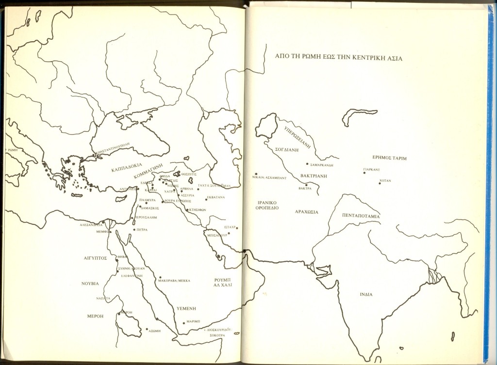
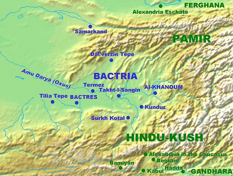
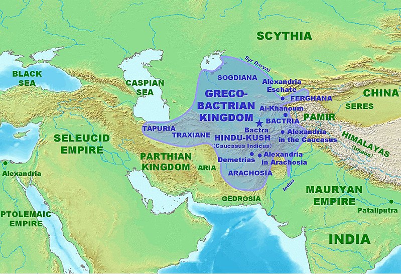
Η Βακτριανή είναι ο χώρος του σημερινού βόρειου Αφγανιστάν και των προς αυτό συνοριακών περιοχών του Τουρκμενιστάν, του Ουζμπεκιστάν και του Τατζικιστάν. Η Βακτριανή είναι μια μεγάλη κοιλάδα που περικλείεται από τα Παμίρ στα βόρεια και στα ανατολικά και από τον Ινδοκαύκασο (Χιντού Κους) στα νότια. Στα δυτικά η κοιλάδα εκτείνεται μέχρι την Σογδιανή που βρίσκεται στα βόρεια και βορειοδυτικά της Βακτριανής και είναι πολύ πιο πεδινή χώρα. Πρωτεύουσα της Βακτριανής ήταν τα Βάκτρα (σήμερα Μπαλχ) που αποτελούσαν πολύ σημαντικό κέντρο πολιτισμού πάνω στους Ιστορικούς Δρόμους του Μεταξιού στα προϊσλαμικά και στα ισλαμικά χρόνια. Δυστυχώς σχεδόν τα πάντα από τα αρχαία, προϊσλαμικά, Βάκτρα έχουν χαθεί, διότι θα έπρεπε να εκκενωθεί η πόλη Μπαλχ για να γίνουν εκτεταμένες ανασκαφές, αν και βέβαια το περίφημο κάστρο του Μπαλχ σαφέστατα και αντιστοιχεί στην αρχαία, προϊσλαμική ακρόπολη των Βάκτρων.
Οι σήμερα σωζόμενοι, ανεσκαμμένοι και μελετημένοι χώροι του επίκεντρου της Αρχαίας Βακτριανής είναι: το Τίλια Τεπέ (Tilia Tepe), όπου ο Ρωσσο-Ποντιος Βίκτωρ Σαριγιαννίδης έφερε στο φως τα πιο εντυπωσιακά βακτριανικά μνημεία και απίστευτο αριθμό χρυσών αντικειμένων, το Τερμέζ (Termez), το Σουρχ Κοτάλ (Surkh Kotal), το Κουντούζ (Kunduz), το Ταχτ-ι Σανγκίν (Takht-i Sangin), το Νταλβερζίν Τεπέ (Dalverzin Tepe), και το Άι Χανούμ (Ai Khanoum). Βεβαίως η Βακτριανή εξικνείται και πιο νότια μέχρι την Αλεξάνδρεια του Καυκάσου (η μεταγενέστερη Καπίτσα, πρωτεύουσα της Αυτοκρατορίας του Κουσάν) και το Μπαγκράμ (Begram), στις νότιες υπώρειες του Ινδοκαύκασου λίγο βορειώτερα της Καμπούλ. Αλλά η Βακτριανή δεν φθάνει τόσο βόρεια όσο η Αλεξανδρεια Εσχάτη στην Κοιλάδα της Φεργάνα, βορείως των Παμίρ: εκείνη η περιοχή είναι τμήμα της Σογδιανής.
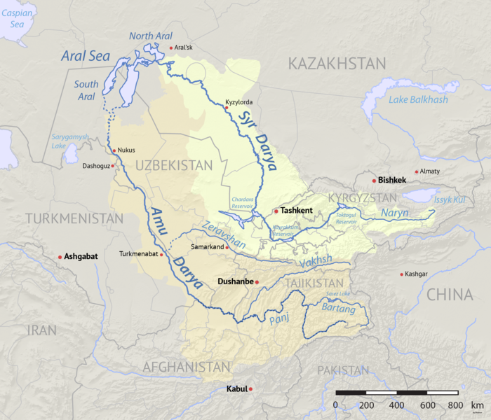
Κεντρικό γεωγραφικό χαρακτηριστικό της Βακτριανής είναι το γεγονός ότι η χώρα διασχίζεται από τον Ώξο (αρχαία ιρανικά: Γιάχσα), ένα μεγάλο ποτάμι που σήμερα ονομάζεται Αμού Ντάρυα κι εκβάλλει στην Αράλη, όπου επίσης εκβάλλει, ρέοντας πολύ πιο ανατολικά, και ο Ιαξάρτης (αρχαία ιρανικά: Γιάχσα Άρτα: ‘Άνω Ώξος’), ο οποίος σήμερα λέγεται Συρ Ντάρυα. Ο Ώξος (Αμού Ντάρυα) σχηματίζεται από την συμβολή πολλών παραποτάμων που σχηματίζονται στα βουνά που περιβάλλουν την Βακτριανή από τα βόρεια, τα ανατολικά και τα νότια: ο Παντζ και ο Κόκτσα είναι δύο από αυτούς τους παραποτάμους.
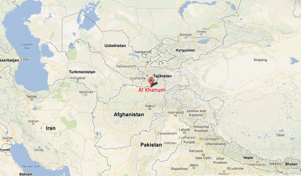
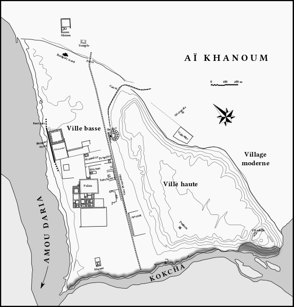
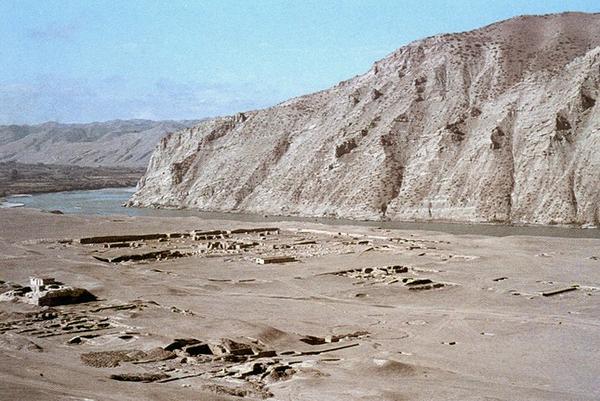
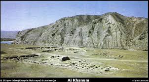
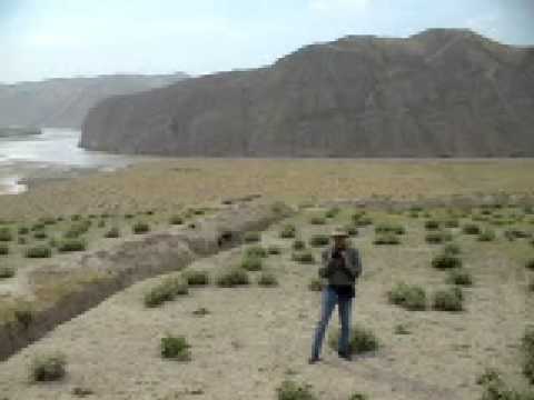
Η Άι Χανούμ (Ἀλεξάνδρεια ἡ ἐπὶ τοῦ Ώξου) έχει ανεγερθεί στην συμβολή αυτών των δύο παραποτάμων του Ώξου, του Παντζ και του Κόκτσα. Επειδή ο Παντζ είναι ήδη πολύ μεγαλύτερος του Κόκτσα, οι Αρχαίοι Έλληνες που θεμελίωσαν εδώ μια πόλη εξέλαβαν τον Παντζ ως τον αρχικό ρου του Ώξου. Το νεώτερο, ουζμπεκικό όνομα της περιοχής και του κοντινού χωριού σημαίνει ‘η Κυρία Σελήνη’ και αναφέρεται σε μια ντόπια γυναίκα της οποίας το όνομα ήταν Άι (‘σελήνη’). Αντίθετα με τις αραβικές λέξεις για την σελήνη που μπορούν να είναι ονόματα ανδρών (όπως π.χ. Μπαντραντίν: ‘φεγγάρι της θρησκείας’), στις τουρανικές (Turkic) γλώσσες η λέξη ‘σελήνη’ είναι όνομα γυναικών. Το σημείο βρίσκεται πολύ κοντά στην μεθόριο του Τατζικιστάν.
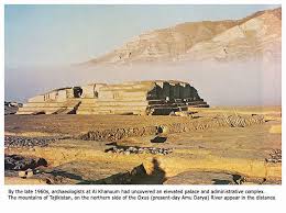
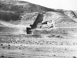
Η Άι Χανούμ ως χώρος αρχαιοτήτων ανακαλύφθηκε μόλις στην δεκαετία του 1960 από τον Χαν Γολάμ Σερβάρ Νασέρ, ο οποίος εξαιτίας των ευρημάτων που εντοπίστηκαν εκεί κάλεσε τον Αμερικανό αρχαιολόγο Daniel Schlumbergerτου οποίου ομάδα γρήγορα ταύτισε τον χώρο με την μέχρι τότε γνωστή μόνον χάρη σε ιστορικές πηγές Αλεξάνδρεια επί του Ώξου. Οι πιο συστηματικές ωστόσο ανασκαφές έγιναν από τον Γάλλο αρχαιολόγο Paul Bernard της Γαλλικής Αρχαιολογικής Αντιπροσωπείας στο Αφγανιστάν (DAFA: Délégation archéologique française en Afghanistan) από το 1964 μέχρι το 1978.
Το 1978 οι ανασκαφές διακόπηκαν λόγω της σοβιετικής εισβολής και μάλιστα στο συγκεκριμένο σημείο έγιναν συγκρούσεις επειδή οι γαλλικές μυστικές υπηρεσίες (δηλαδή οι ίδιοι οι αρχαιολόγοι κι οριενταλιστές της ομάδας του DAFA), περιμένοντας την σοβιετική εισβολή, είχαν ήδη οργανώσει ένοπλες ομάδες Τατζίκων του Αφγανιστάν για να αντιμετωπίσουν τους Σοβιετικούς ή να οργανώσουν σχετική αντίσταση μετά την κατάληψη. Αυτοί οι πρώτοι αντιστασιακοί κατά των Σοβιετικών, πρέπει να τονιστεί, ήταν μουσουλμάνοι αλλά δεν ήταν ισλαμιστές, δεν είχαν επαφή με την Σαουδική Αραβία, κι απλώς δεν ήθελαν να γίνουν τμήμα της ΕΣΣΔ. Μετά από πολλές δεκαετίες, ο David Adams το 2013 γύρισε ένα ντοκυμαντέρ σχετικά με τις αρχαιότητες που είχαν ανασκαφεί στην Άι Χανούμ με τίτλο Alexander’s Lost World.
Είναι πιθανόν η Αλεξάνδρεια επί του Ώξου να ταυτίζεται με την γνωστή απο ποικίλες ιστορικές πηγές Ευκρατίδεια, ή αλλοιώς και Ευκρατιδία ( اروکرتیه – Arukratiya – Eucratidia), την οποία ανήγειρε (ή επεξέτεινε) ο Ευκρατίδης Α’ ο Μέγας (170-145 π.Χ.). Δεν υπάρχει ακόμη συμφωνία ειδικών αν η πόλη ανεγέρθηκε στα τέλη του 4ου προχριστιανικού αιώνα από τον Αντίοχο Σωτήρα Α’, ή στις αρχές του 3ου προχριστιανικού αιώνα, ή ακόμη κατά τον 2ο προχριστιανικό αιώνα. Πάντως το πιθανώτερο είναι η πόλη να θεμελιώθηκε τον 3ο προχριστιανικό αιώνα και να καταστράφηκε στις νομαδικές επιδρομές του 145 π.Χ.
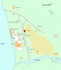
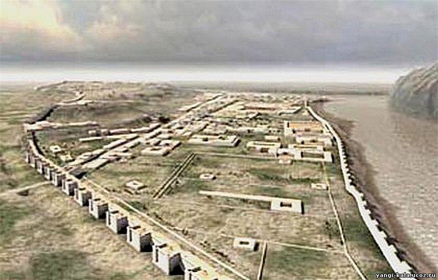
Η μεγάλη πολιτεία (1.5 τχ) με θέατρο, γυμνάσιο, ανάκτορο και κτήρια ελληνικής αρχιτεκτονικής τεχνοτροπίας είχε πολλά κεντρασιατικά, βακτριανικά, χαρακτηριστικά – δείγμα ότι οι κάτοικοι ήταν ανάμεικτοι Έλληνες και Βακτριανοί.
Υπήρχαν μεγάλα τείχη μήκους σχεδόν 4 χμ, ακρόπολη με πύργους, και διάφοροι ναοί όπου ένας βακτριανο-ελληνικός συγκρητισμός σημειώνεται στην αρχιτεκτονική δομή και στην διακόσμηση. Πολλά αγάλματα, ανάγλυφα κι αρχαιοελληνικές επιγραφές έχουν ανασκαφεί και κάποιες επιγραφές αποτελούν δελφικά παραγγέλματα (https://el.wikipedia.org/wiki/Δελφικά_παραγγέλματα).
Για παράδειγμα:
παῖς ὢν κόσμιος γίνου,
ἡβῶν ἐγκρατής,
μέσος δίκαιος,
πρεσβύτης εὔβουλος,
τελευτῶν ἄλυπος.
Δείτε το βίντεο:
Ай Ханум – Александрия Оксианская: древний город Греко-Бактрийского царства в северном афганистане
Ай-Ханум (перс. آیخانم, узб. Oyxonim), Александрия Оксианская (др.-греч. Ἀλεξάνδρεια ἡ ἐπὶ τοῦ Ὄξου) — древний город Греко-Бактрийского царства, руины которого располагаются в районе Дашти-Кала[en] афганской провинции Тахар, близ границы с Таджикистаном, на левом берегу реки Пяндж у устья реки Кокча. Городище является уникальным памятником эллинистической культуры в Центральной Азии.
Уже в эпоху бронзового века на территории города существовало поселение. Во время походов Александра Македонского, вероятно, здесь предполагалось основать крупный город, форпост восточной Бактрии. Однако реальное заселение датируется временем Селевка Никатора и относится к рубежу IV—III вв. до н. э. Расцвет города приходится на III—II вв. до н. э., когда были возведено большинство зданий. Разрушение города связывается с нашествием индоевропейских кочевых племен (вначале скифов-саков, затем тохаров, или юэчжи) на Бактрию в середине II в. (около 135 г. до н. э.). С тех пор город больше не восстанавливался.
Открытие и исследование города связано с именем афганского короля Захир-Шаха, большого любителя древностей. Во время одного из путешествий короля по регионам страны представители местной администрации устроили для короля традиционную охоту на тигра, но зная о исторических увлечениях Захир-шаха, обставили её так, чтобы маршрут лова проходил по территории, «…где из земли торчали каменные столбы». Король, естественно, обнаружил остатки древних строений и сообщил об этом Даниэлю Шлюмберже, занимавшему тогда пост директора Французской археологической миссии в Афганистане.
Шлюмберже со своим помощником Полем Бернаром выехали на место. Уже сам осмотр территории городища и характер подъёмного материала позволил говорить о уникальном открытии эллинистического города в глубинах Азии (1964 г.). Это открытие существенно изменило представления о характере и качественных характеристиках эллинистической культуры в Азии.
Ещё с XVIII в. европейским учёным были известны монеты высокого качества с удивительно искусно выполненными портретами греческих царей Бактрии. Однако зримых памятников бактрийской культуры, подобных Риму, афинскому Акрополю, или персидскому Персеполю обнаружено не было. Поэтому исследователи оперировали в основном материалами последующих эпох, реконструируя на их основе античную культуру Центральной Азии. Несмотря на огромное количество материалов кушанской эпохи, говорящих о устойчивой античной основе, отсутствие непосредственно эллинистических памятников (за исключением монет) представлялось досадным недоразумением. Особенно остро вопрос об эллинистической культуре Бактрии встал после неудачи с зондажами в Балхе, где эллинистические слои были либо частично скрыты из-за высоко уровня грунтовых вод, или же давали невыразительный материал, что побудило выдвинуть тезис о «бактрийском мираже» (Фуше в 1925 г.), говорящим о том, что Бактрия была слаборазвитой страной, монетные формы для которой делали приезжие греческие мастера, а античные мотивы в буддийские памятниках объяснялись римским (!) влиянием. Более трезво мыслящие исследователи, среди которых особенно выделялся Д. Шлюмберже, предполагали, что отсутствие эллинистических памятников связано с плохой изученностью региона.
Однако ситуация усугублялась общей слабой изученностью эллинистических памятников Востока, что давало повод говорить о слабости греко-македонской колонизации и периферийном значении восточного региона в системе всей античной культуры. Но, как впоследствии оказалось, слабая изученность эллинистической культуры Востока была связана именно с греко-македонской колонизацией, так как большинство современных городов этого региона возникло именно в ту эпоху. Ай-Ханум был единственным крупным эллинистическим городом в Центральной Азии, сохранившимся в таком хорошем состоянии и давшим эталонные памятники эллинистической культуры мирового уровня.
Ай-Ханум (перс. آیخانم, узб. Oyxonim), Александрия Оксианская (др.-греч. Ἀλεξάνδρεια ἡ ἐπὶ τοῦ Ὄξου) — древний город Греко-Бактрийского царства, руины которого располагаются в районе Дашти-Кала[en] афганской провинции Тахар, близ границы с Таджикистаном, на левом берегу реки Пяндж у устья реки Кокча. Городище является уникальным памятником эллинистической культуры в Центральной Азии.
Структура греко-бактрийского города была продиктована геологическим строением материкового останца, состоящего из нескольких террас, в соответствии с которыми город делится на три части: Нижний город, на территории которого сосредоточены основные исследованные объекты:
Дворцовый комплекс
Гимнасий
Жилые дома
Героон Кинея (предположительно основателя города)
Храм-мавзолей
Арсенал
Главный храм — сооружение в вавилонском стиле с греческой статуей Зевса внутри
Театр — единственное сооружение подобного рода, открытое в Средней Азии
Акрополь — верхний город, научно практически не исследовался
Цитадель — небольшое укрепление в южном углу акрополя
На развалинах монументального здания эллинистического периода был построен обжигательный горн, когда город Ай-Ханум практически не существовал.
Άι Χανούμ – Αλεξάνδρεια επί του Ώξου: Ελληνική Πόλη των Επιγόνων στην Βακτριανή (Βόρειο Αφγανιστάν)
Περισσότερα:
Curtius 7.10.15: Κουίντος Κούρτιος Ρούφος, Historia Alexandri Magni regis Macedonum, βιβλίο έβδομο, κεφ. 10
«…Superatis deinde amnibus Ocho et Oxo, ad urbem Margianam pervenit. Circa eam VI oppidis condendis electa sedes est. Duo ad meridiem versa, IIII spectantia orientem;…»
(μετάφραση:«…Τότε πέρασε τους ποταμούς Ώξο και Ώχο και έφτασε στην πόλη της Μαργιάνα. Γύρω της ίδρυσε έξη πόλεις, δύο νότια και τέσσεριες ανατολικά…»)
Ai-Khanoum (Aï Khānum, also Ay Khanum, lit. “Lady Moon” in Uzbek), possibly the historical Alexandria on the Oxus (Greek: Ἀλεξάνδρεια ἡ ἐπὶ τοῦ Ώξου), possibly later named Eucratidia, Εὐκρατίδεια) was one of the primary cities of the Greco-Bactrian Kingdom from circa 280 BCE, and of the Indo-Greek kings when they ruled both in Bactria and northwestern India, from the time of Demetrius I (200-190 BCE) to the time of Eucratides (170–145 BCE). Previous scholars have argued that Ai Khanoum was founded in the late 4th century BC, following the conquests of Alexander the Great. Recent analysis now strongly suggests that the city was founded c. 280 BC by the Seleucid emperor, Antiochus I Soter. The city is located in Takhar Province, northern Afghanistan, at the confluence of the Panj River and the Kokcha River, both tributaries of the Amu Darya, historically known as the Oxus, and at the doorstep of the Indian subcontinent. Ai-Khanoum was one of the focal points of Hellenism in the East for nearly two centuries until its annihilation by nomadic invaders around 145 BCE about the time of the death of Eucratides I.
The choice of this site for the foundation of a city was probably guided by several factors. The region, irrigated by the Oxus, had a rich agricultural potential. Mineral resources were abundant in the back country towards the Hindu Kush, especially the famous so-called “rubies” (actually, spinel) from Badakshan, and gold. Its location, at the junction between Bactrian territory and nomad territories to the north, ultimately allowed access to commerce with the Chinese empire. Lastly, Ai-Khanoum was located at the very doorstep of Ancient India, allowing it interact directly with the Indian subcontinent.
Numerous artefacts and structures were found, pointing to a high Hellenistic culture, combined with Eastern influences. “It has all the hallmarks of a Hellenistic city, with a Greek theatre, gymnasium and some Greek houses with colonnaded courtyards” (Boardman). Overall, Aï-Khanoum was an extremely important Greek city (1.5 sq kilometer), characteristic of the Seleucid Empire and then the Greco-Bactrian Kingdom. It seems the city was destroyed, never to be rebuilt, about the time of the death of the Greco-Bactrian king Eucratides around 145 BC. Ai-Khanoum may have been the city in which Eucratides was besieged by Demetrius, before he successfully managed to escape to ultimately conquer India (Justin).
The mission unearthed various structures, some of them perfectly Hellenistic, some other integrating elements of Persian architecture:
– Two-miles long ramparts, circling the city
– A citadel with powerful towers (20 × 11 metres at the base, 10 meters in height) and ramparts, established on top of the 60 meters-high hill in the middle of the city
– A Classical theater, 84 meters in diameter with 35 rows of seats, that could sit 4,000-6,000 people, equipped with three loges for the rulers of the city. Its size was considerable by Classical standards, larger than the theater at Babylon, but slightly smaller than the theater at Epidaurus.
– A huge palace in Greco-Bactrian architecture, somehow reminiscent of formal Persian palatial architecture
– A gymnasium (100 × 100m), one of the largest of Antiquity; A dedication in Greek to Hermes and Herakles was found engraved on one of the pillars. The dedication was made by two men with Greek names (Triballos and Strato, son of Strato).
– Various temples, in and outside the city. The largest temple in the city apparently contained a monumental statue of a seated Zeus, but was built on the Zoroastrian model (massive, closed walls instead of the open column-circled structure of Greek temples).
– A mosaic representing the Macedonian sun, acanthus leaves and various animals (crabs, dolphins etc…)
– Numerous remains of Classical Corinthian columns
On a hunting trip in the 1960s, the Afghan Khan Gholam Serwar Nasher discovered ancient artefacts of Ai Khanom and invited Princeton archaeologist Daniel Schlumberger with his team to examine Ai-Khanoum. It was soon found to be the historical Alexandria on the Oxus, also possibly later named اروکرتیه Arukratiya or Eucratidia), one of the primary cities of the Greco-Bactrian kingdom. Some of those artefects were displayed in Europe and USA museums in 2004. The site was subsequently excavated through archaeological work by a French Archaeological Delegation in Afghanistan (DAFA) mission under Paul Bernard between 1964 and 1978, as well as Soviet scientists. The work had to be abandoned with the onset of the Soviet–Afghan War, during which the site was looted and used as a battleground, leaving very little of the original material. In 2013, the film-maker David Adams (photojournalist) produced a six-part documentary mini-series about the ancient city entitled Alexander’s Lost World.
На каком основании узбекские власти отобрали древний город у Афганистана
АНДРЕЙ КУДРЯШОВ 29.08.19
Есть в Узбекистане античное городище Кампыртепа, расположенное в 30 километрах к западу от Термеза. 24 августа в рамках археолого-туристического форума «Узбекистан — перекресток цивилизаций» на территории этого городища состоялось торжественное открытие археологического памятника — Александрии Оксианской. Звучит сенсационно — особенно для тех, кто думал, что город-крепость Александрия Оксианская была построена в IV веке до нашей эры Александром Македонским во время его военных походов в Бактрию и находилась в Афганистане, в провинции Тахар.
Заместитель премьера Узбекистана Азиз Абдухакимов и хоким Сурхандарьинской области Тура Боболов перерезали символическую алую ленточку и объявили, что с этого дня именно археологический памятник Кампыртепа признан Александрией Оксианской и так он и будет теперь официально называться. Более того, на автомобильных трассах, ведущих к древнему городищу, уже установлены соответствующие указатели. Ученые, общественные деятели и журналисты, приглашенные на конференцию из сорока стран, в течение часа подробно осматривали живописные руины на берегу Амударьи, которую в античные времена называли Окс, — отсюда и Оксианская в названии здешней Александрии.
Научной основой для пиар-акции по открытию Александрии Оксианской на территории Узбекистана послужила недавно изданная в Ташкенте брошюра академика Академии наук Узбекистана Эдварда Васильевича Ртвеладзе. Брошюра эта носит сенсационное название «Кампыртепа — Александрия Оксианская: город-крепость на берегу Окса». В своей работе известный археолог оспаривает распространенное в научных кругах мнение, будто Александрия Оксианская располагалась в Афганистане, — там, где на левом берегу Пянджа находится городище Ай-Ханум.
Ай-Ханум был обнаружен французскими археологами Даниэлем Шлюмберже и Полем Бернаром в 1964 году. Случилось это, как говорят, по «подсказке» афганского короля Захир-Шаха. На территории Ай-Ханум нашли типичные греческие строения, которых не было на Кампыртепе: театр, агору и гимнасий.
Считается, однако, что реальное заселение этого греческого города не было связано с походами Александра Македонского. Оно началось лишь после распада его империи — в период правления диадоха Селевка I Никатора, который при жизни Александра Македонского был телохранителем великого полководца. Таким образом, расцвет поселения пришелся уже на эпоху Греко-Бактрийского царства (III-II века до нашей эры).
Древнегреческий историк Плутарх приписывал Александру Македонскому основание 70 городов — начиная от Малой Азии и Египта и вплоть до Индии. Современные историки, правда, полагают, что 60 из этих 70 городов существовали и до великого завоевателя, но были укреплены или перестроены его армией. Большинство же прочих Александрий достраивались и заселялись уже после смерти великого полководца.
Современная история Ай-Ханум сложилась достаточно печально. После сворачивания в 1978 году археологических работ городище разрушили местные жители. Они выкопали здесь множество ям — искали древние сокровища. Несмотря на это, Ай-Ханум до сих пор считается единственным крупным эллинистическим городом в Центральной Азии, городом, давшим эталонные памятники эллинистической культуры мирового уровня.
Городище Кампыртепа открыл Эдвард Ртвеладзе в 1972 году. Первоначально полагали, что археологи имеют дело с небольшой крепостью, охранявшей переправу через Амударью во времена Кушанского царства. Основные постройки Кампыртепы представляли собой цитадель, окруженную рвом, и «нижний город» с узкими улицами, который со стороны суши защищала крепостная стена с башнями. В ближайших окрестностях городища были также найдены керамические мастерские. Благодаря спонсорской поддержке конгресса США в начале 2000-х годов удалось восстановить часть внешней крепостной стены и одного кушанского квартала. Сделано это было с применением древних строительных методов. В частности, для формовки сырцового кирпича тут использовался лёсс, который брали у подножия крепостной стены. В своем нынешнем виде Кампыртепа включена в предварительный Список объектов всемирного наследия, охраняемых ЮНЕСКО.
Исследуя городище, академик Ртвеладзе провел аналогию между Кампыртепой и поселением Бурдагуй, которое упоминал персидский автор XV века Хафизи Абру.
«Бурдагуй — место на берегу Джейхуна (Амударьи), около Термеза. Говорят, оно существовало задолго до Термеза и было основано тоже Александром» — писал Хафизи Абру.
Раскопки ниже кушанского культурного слоя позволили выявить на Кампыртепе и эллинистический слой. Благодаря этому история городища удлинилась до IV века до нашей эры. В последние пять лет академик Ртвеладзе исследовал пойменную низину между Кампыртепой и нынешним руслом Амударьи — сейчас эта низина занята рисовыми полями. Здесь главный археолог Узбекистана сделал находки, которые он трактует как остатки типичной греческой гавани и маяка.
«Свое мнение о локализации Александрии Оксианской на месте Кампыртепа я высказал еще в начале 2000-х годов, хотя в то время археологических данных, подтверждающих этот тезис, имелось еще очень мало, — пишет академик Ртвеладзе в своей брошюре. — Сейчас их выявлено значительно больше. Это прежде всего размеры города-порта, в данное время протянувшегося вдоль Окса с запада на восток более чем на 400 метров, а также развитая градостроительная структура, состоящая из сильно укрепленного фуриона, — крепости с воротами, улицей, святилищем-храмом, некрополем и гаванью, включавшей порт с маяком, бухту для стоянки кораблей и пристань, где находились торговые пункты и ремесленные мастерские. Очевидно, в свете всех полученных данных, что Кампыртепа в конце IV — начале III вв. до н.э. представляла довольно значительное по площади поселение-город с весьма разнообразной структурой, которая ни на Ай-Ханум, ни в Старом Термезе для этого времени археологически не зафиксирована».
Есть, однако, скептики, которые возражают академику. Они замечают, что, хотя на Кампыртепе действительно есть археологические слои, которые можно отнести ко времени походов Александра Македонского в Бактрию, здесь нет убедительных свидетельств монументальной эллинистической архитектуры. По крайней мере, под более поздними культурными слоями они не выявлены. Особенно это касается гавани и маяка. Кампыртепа прекратила свое существование из-за значительного подъема уровня воды в Амударье. Гавань должно было смыть в первую очередь. Современное городище демонстрирует в его прибрежной части легко узнаваемый береговой обрыв. Как же смог ученый обнаружить признаки гавани на поверхности речного русла, вновь обнажившегося спустя два тысячелетия?
Тем не менее сторонники смелой гипотезы Ртвеладзе утверждают, что 77-летний академик имеет ответы на любые каверзные вопросы и открыт к научной полемике. Другой вопрос — нужна ли такая полемика властям Узбекистана? Ведь Кампыртепа, ставшая Александрией Оксианской, чрезвычайно перспективный туристический объект. В начале 2000-х годов в Сурхандарьинскую область, граничащую с воюющим Афганистаном, был запрещен въезд иностранным туристам, да и граждане страны были ограничены в посещениях этой территории. Сейчас же можно совершенно беспрепятственно посетить Термез и все находящиеся в его окрестностях достопримечательности — даже расположенные возле самой границы.
Более того, хоким Сурхандарьинской области Тура Боболов в комментарии «Фергане» сообщил, что власти соседствующих стран планируют организацию упрощенного трансграничного режима для туристов — чтобы человек или группа, интересующиеся артефактами истории древней Бактрии, смогли начать их осмотр в Узбекистане и продолжить в Афганистане.
ВЫСТАВКА ПАМЯТНИКОВ ДРЕВНОСТИ И ПРОИЗВЕДЕНИЙ ИСКУССТВА АФГАНИСТАНА ПРОХОДИТ В СЕУЛЕ
Выставка памятников древности и произведений искусства Афганистана проходит в Национальном музее Сеула в Южной Корее.
«Изюминкой» выставки является знаменитое «золото Бактрии» из района Шибиргана.
Кроме того, посетители имеют возможность ознакомиться с произведениями греко-бактрийского искусства из городища Ай-Ханум, оно же «Александрия Оксианская» – города, расцвет которого пришелся на 1У в. до Р.Х. – 11 в. Р.Х., руины которого были обнаружены в 60-е годы ХХ в. французскими и советскими археологами в провинции Кундуз.
Городище являлось уникальным памятником эллинистической культуры в Центральной Азии.
Помимо собственно золота, в выставочной коллекции представлены серебряные украшения, различные изделия из стекла и керамики, а также скульптура и произведения мелкой пластики из известняка.
Как рассказал радио «Ашна» директор Национального музея Афганистана Фахим Рахими, показ коллекции произведений искусства и памятников древней культуры Афганистана в зарубежных музеях приносит стране пользу как с материальной, так и с духовно-нравственных точек зрения.
Указав на морально-нравственную ценность данной выставки, Рахими добавил, что ознакомление с памятниками древности позволит людям других стран ближе соприкоснуться с уникальной афганской культурой и древней историей.
По словам Рахими, первая выставка «золота Бактрии» и других древностей была организована в 2011 году в Париже. К настоящему моменту она уже объехала 11 стран мира, в частности Францию, Голландию, Германию, Норвегию, Великобританию, США и Канаду. Принято решение, что выставка будет проходить в различных музеях Южной Кореи до 27 ноября этого года.
Δείτε το βίντεο: Ай Ханум – Александрия Оксианская, Ai Khanoum – Alexandria on the Oxus, Αλεξάνδρεια επί του Ώξου
Περισσότερα:
Bactria, the territory of which Bactra was the capital, originally consisted of the plain between the Hindu Kush and the Āmū Daryā with its string of agricultural oases dependent on water taken from the rivers of Balḵ (Bactra), Tashkurgan, Kondūz, Sar-e Pol, and Šīrīn Tagāō. This region played a major role in Central Asian history. At certain times the political limits of Bactria stretched far beyond the geographic frame of the Bactrian plain.
Bactria in the Bronze and Iron Ages. The first mentions of Bactria occur in the list of Darius’s conquests and in a fragment of the work of Ctesias of Cnidos—texts written after the region’s incorporation in the Achaemenid empire. Ctesias, however, echoes earlier reports in his mention of campaigns by the Assyrian king Ninus and the latter’s wife Semiramis (late 9th and early 8th century B.C.). Thereafter, he states, Bactria was a wealthy kingdom possessing many towns and governed from Bactra, a city with lofty ramparts. A similar picture is presented in the Zoroastrian tradition (Avesta, Šāh-nāma), which speaks of the protection given to Zoroaster by a powerful ruler of Bactra (see ii, below).
While the existence of such a kingdom remains hypothetical, archeological investigations have produced evidence of big oasis communities grouped around a fortress (Dašlī). These communities, like those of the oases in Margiana, were already practicing a well-developed system of irrigation and carrying on trade in products such as bronze and lapis lazuli with India and Mesopotamia.
Bactria under the Achaemenids. After annexation to the Persian empire by Cyrus in the sixth century, Bactria together with Margiana formed the Twelfth Satrapy. Apparently the annexation was not achieved through conquest but resulted from a personal union of the crowns. Indicative of this are the facts that the satrap was always a near kinsman of the great king and that the Achaemenid administrative system was not introduced. The local nobles played a big part and held all real power. Their wealth is attested by the opulence of the Oxus treasure. Bactra occupied a commanding position on the royal road to India. Profits from the east-west trade as well as from the outstandingly prosperous local agriculture enabled the province to pay a substantial tribute (360 talents of silver per annum).
The Bactrians also made an important contribution to the Persian army. At Salamis they were under the great king’s direct command. At Gaugamela the Bactrian cavalry nearly turned the scales against the Macedonians. When Darius Codomannus, after his defeat in this battle, sought refuge in the Upper Satrapies, the Bactrian Bessos caused him to be murdered and then proclaimed himself king. Despite the resistance by scorched earth tactics conducted by Bessos, Bactria was conquered by the Macedonians and Bessos was delivered to them and put to death on Alexander’s order. Bactra then served as Alexander’s headquarters during his long campaign into Sogdia. After overcoming all the forces of resistance, Alexander took away 30,000 young Bactrians and Sogdians as hostages and incorporated a large number of Bactrians in his army. At the same time he settled many of his veterans in colonies planned to secure the Macedonian hold on Bactria.
Little information has been obtained from Achaemenid sites in Bactria. Bactra is deeply buried under the citadel (bālā-ḥeṣār) of present-day Balḵ. Drapsaca and Aornos, mentioned by the historians of Alexander, are usually identified with Kondūz and Tashkurgan, where excavations have yet to begin. More recently it has been suggested that Aornos may have been located at Altyn Delyār Tepe (Rtveladze, pp. 149-52), a site north of Balḵ where excavation was started but could not be pursued. Other sites from the Achaemenid period are Kyzyl Tepe and Talaškan Tepe on the Sorḵān Daryā, and Taḵt-e Qobād (the probable source of the Oxus treasure) on the right bank of the Oxus, the citadel of Delbarjīn, and the circular town of Āy Ḵānom II on the left bank. All show traces of fortifications built of dried mud or large bricks on massive platforms. At none of them has thorough exploration yet been possible.
Āy Ḵānom or Aï Khanum (Tepe), a local Uzbek name (lit. Lady Moon hill) designating the site of an important Greek colonial city in northern Afghanistan excavated since 1965 by a French mission and which belonged to a powerful hellenistic state born of Alexander’s conquest in Central Asia (329-27 B.C.). Centered around Bactriana, the middle valley of the Oxus (Amu Darya), this colonized area was first part of the Seleucid empire, then, around 250 B.C., it became an independent kingdom which remained under Greek rule until approximately 150 B.C. when it was destroyed by nomad invasions from the northern steppes.
The city of Aï Khanum which controlled a fertile agricultural plain irrigated by an extensive system of canals (J.-Cl. Gardin and P. Gentelle, Bulletin de l’Ēcole française d’Extrême Orient, 1976, pp. 59-99) and a mountainous back-country (Badaḵšān) rich in minerals and semiprecious stones (rubies, lapis), was built at the junction of the Oxus river and of one of its left-bank affluents, the Kokča. Roughly triangular in shape (1,800 by 1,600 m), it encompassed within a girt of powerful mud-brick ramparts (P. Leriche, Fouilles d’Aï Khanoum IV: Les remparts d’Aï Khanoum, Paris, 1986) a lower town where most of the buildings were located and an acropolis on a hill (P. Bernard and D. Schlumberger, Bulletin de correspondance hellénique, 1965, pp. 595-657; P. Bernard, Proc. British Academy, 1967, p. 71-95).
Outside the ramparts lay a suburb and the necropolis. Although the Greek colonists kept their national language and way of life, the architecture of the town, combining mud-brick walls and stone columns and pillars, reveals a mixture of Greek and oriental traditions (P. Bernard, Comptes rendus de l’Académie des inscriptions et belles letters, 1966, pp. 127-33; 1967, pp. 306-24; 1968, pp. 263-79; 1969, pp. 313-55; 1970, pp. 301-49; 1971, pp. 387-452; 1972, pp. 605-32; 1974, pp. 280-308; 1975, pp. 167-97; 1976, pp. 287-322; idem, JA, 1976, pp. 245-75; P. Bernard et al., Fouilles d’Aï Khanoum I, pp. 1-120; Bulletin de l’Ēcole française d’Extrême Orient, 1976, pp. 6-51). Columnated porticoes of the Corinthian, Doric, and more rarely Ionic orders (P. Bernard, Syria, 1968, pp. 111-51) bespeak the hellenistic tradition as do the antefixes and tiles of the roofs and such typical buildings as a gymnasium, a theater, a fountain, and funerary monuments.
The gymnasium, of colossal proportions, consisted of several courtyards surrounded by rooms, of which the two principal ones were devoted to physical training and intellectual activities, and included extensive bath-facilities (S. Veuwe, Fouilles d’Aï Khanoum VI: Le gymnase, Paris, 1987). In the theater, made entirely of mud bricks and as large as the one in Babylon, the usual tiered rows of seats were interrupted by loggias for prominent people. In a fountain a water-spout carved to represent one of the characters of Greek comedy proves that the theatrical repertory itself was Greek. Funerary monuments for eminent citizens were built inside the ramparts and imitated Hellenic temples. In the most ancient of them—and the most modest—a certain Kineas was buried, who may have been the city’s founder.
In the precinct of this heroon a stele, on which was engraved a copy of the famous Delphic maxims which embody Greek wisdom, had been erected (L. Robert in Fouilles d’Aï Khanoum I, pp. 207-37). Alongside these buildings of Hellenic types there were others of Oriental tradition in which local elements were fused with Iranian and even Mesopotamian ones.
Three temples have been discovered, none of which has a Greek plan. One of them, a simple stepped podium in open air on the acropolis, is clearly related to Iranian and Central Asian sanctuaries of the Achaemenid period. Another, standing on a three-stepped platform, with a square plan and a broad vestibule leading to a smaller cella flanked by two sacristies, and whose walls are decorated with indented recesses, is also purely Oriental and can be compared with certain Parthian temples at Dura Europos. A third temple with a triple cella has the same wall-decoration and stepped platform. Although the official pantheon, as it appears on the coinage of the Greco-Bactrian kingdom, was, with a few exceptions, purely Greek (Cl. Petitot, RN, 1975, pp. 23-57; P. Bernard, ibid., pp. 58-69; 1973, pp. 238-89; 1974, pp. 6-41; Fouilles d’Aï Khanoum IV: Les monnaies hors trésors, Paris, 1985), this type of religious architecture implies a strong influx of local beliefs in the city-cults and suggests divinities of a syncretic nature.
The vast patrician mansions, with their front courtyard and the disposition of the secondary rooms grouped around the principal one which is usually surrounded by a peripheral corridor, except for the spacious bathrooms, have nothing to do with the traditional Greek houses (P. Bernard, JA, 1976, pp. 257-66). A huge arsenal housed the military equipment (F. Grenet, Bulletin de l’Ēcole française d’Extrême Orient, 1980, pp. 51-63). The city’s main building was a monumental palace—probably the governor’s—approximately 300 m2, which was situated in the middle of the lower town. It comprised several courtyards, two of them possessed columned porticoes, residential quarters, administrative sections with offices and reception rooms, and also a treasury in which was found a large number of storage jars, several of them bearing economic inscriptions in Greek (Cl. Rapin, Bulletin de correspondence hellénique, 1983, pp. 315-72), a large amount of fragments of cut and uncut semi-precious stones, among them a great quantity of lapis lazuli, and fragments of Greek literary papyri.
Although the columns and antefixes give a certain Greek aura, the compact aggregation of several ensembles in the same compound linked by a complex crisscrossing of corridors, the plan of certain units, the monumentality of proportions, and the repetitious symmetry, all point to Oriental conceptions. Similarly the pottery offers examples of Greek types as well as purely local forms (J.-Cl. Gardin in Fouilles d’Aï Khanoum I, pp. 121-88).
In the field of fine arts, the Greek colonists were much more conservative and seemed to have been satisfied with traditional Greek productions, as can be seen from fragments of stone statuettes, from the water-spouts of a fountain representing respectively a dolphin-head, a dog-head and a comic mask, and from the pebble-mosaics which paved the bath-rooms of the palace and were decorated with floral and animal designs (P. Bernard, Bulletin de l’Ēcole française d’Extrême Orient, 1976, pp. 6-24).
A beautiful medallion in gilt silver, figuring the goddess Cybele on her lion-driven chariot, followed by one of her priests holding an umbrella over her and facing another one who sacrifices at an altar, represents, through its flat Hieratic style, a rare exception to this general trend (P. Bernard, Comptes rendus de l’Académie des inscriptions et belles lettres, 1970, pp. 339-47).
Fragments of life-size statues modeled in clay or stucco attest the introduction of a technique which was subsequently spread all over Central Asia. As one might expect in such a wealthy and urbanized society, workshops were active in producing all kinds of artifacts both for utilitarian purposes, for example grindstones of a specifically Greek type, and for the luxury market such as carved ivories (P. Bernard, Syria, 1970, pp. 327-43) and vessels of dark schist inlaid with colored stones (H.-P. Francfort, Arts Asiatiques, 1976, pp. 91-95).
Hellenistic Bactria The future of the Greek colonization of Bactria hung in the balance when the colonists rebelled in 326, after learning of Alexander’s death, and again in 323; but they were reduced to obedience, and Bactria was then combined with Sogdia to form a satrapy under Philippos. After the establishment of the Seleucid regime, Bactra became for a time the headquarters of Seleucos I’s son Antiochos, who was deputed to defend the eastern satrapies against the growing might of the Mauryan empire. The weakening of Seleucid power particularly in the reign of Antiochos II (261-247) enabled first Parthia, then Bactria to secede. The independent kingdom of Bactria was founded by Diodotos. On coins minted at Bactra the figure of Antiochos is replaced with that of Diodotos over the royal title (the figure on the reverse being Zeus brandishing a thunderbolt).
In 208 Antiochos III set out to reestablish Seleucid authority and marched into Bactria. After fending off a move by the Bactrian cavalry to halt his advance, he blockaded their king Euthydemos in the city of Bactra. The siege dragged on for two years, and in the end Antiochos had to recognize Bactria’s independence and sign a treaty of alliance with Euthydemos.
The Greco-Bactrian kingdom was bounded in the south by the Paropamisadai (Hindu Kush) and in the east by the mountains of Badaḵšān. In the west it was in direct touch with the Parthians, who recovered Parthyene after the departure of Antiochos III and seized the Marv oasis. Scholars now generally accept the view that its northern frontier lay on the line of the Ḥeṣār mountains (between the Oxus and Zarafšān valleys; Bernard and Francfort, pp. 4-16) rather than the view, based on the rarity of finds of Greek coins north of the Oxus, that it lay on that river (Zeĭmal’, pp. 279-90). These frontiers shifted in the course of the kingdom’s career. In the north, Sogdia was annexed at an uncertain date. In the south, a campaign of conquest launched by Demetrios I about 190 led to the creation of a Greco-Indian kingdom with its center at Taxila, but relations did not remain close for long. The Greco-Indian kingdom survived for half a century after the collapse of the Greco-Bactrian kingdom.
The Hellenistic period appears to have been a prosperous time for Bactria. One indication of this is the high quality of its coin issues. Strabo echoes memories of the period when he speaks of “Bactria of the thousand towns.” Until recently, however, archeological investigations, mainly at Balḵ (Bactra) and Termeḏ, were so fruitless that A. Foucher could speak of the “Bactrian mirage.” The situation has been radically changed since 1964, when the remains of a large city were discovered at Āy Ḵānom. Excavations, vigorously pursued until 1978, have shown that this city at the confluence of the Oxus and the Kūkča river was the capital of eastern Bactria. Strongly fortified and dominated by an acropolis and citadel, it was built on a regular plan well suited to the site and had a number of fine edifices typical of a Hellenistic city: a heroon (monument to the founder), gymnasium, theater, fountain with sculptures, and peristyle courts. On the other hand, the huge palace occupying the central position and the upper class dwellings are clearly influenced by Iranian concepts, while the temples and the fortifications show signs of Mesopotamian inspiration.
The abundant and datable material from Āy Ḵānom provided guidance for other site investigations, which were pursued with vigor on both sides of the Oxus. These have revealed the great scale of the irrigation projects undertaken to complete the already substantial works of the preceding periods. Furthermore several new sites of towns or fortified settlements were identified and provisionally excavated, though Termeḏ (probably a foundation of Demetrios) remained inaccessible. In general these are sites of towns founded in the later years of the kingdom’s existence; they are smaller than those of the cities founded by the Seleucids and have a markedly military character, with a citadel overlooking a geometrically planned settlement surrounded by ramparts. Noteworthy are the quadrangular town of Delbarjīn in the north of the Balḵ oasis, and the fortresses of Kay Qobād Šāh, Ḵayrābād Tepe, Qaḷʿa-ye Kāfernegān, and Qarabāḡ Tepe on right bank tributaries of the Oxus. Somewhat later came the discovery of the site on the right bank of the Oxus called Taḵt-e Sangīn, which is surrounded by stone fortifications (most unusual in this region); excavations there have uncovered a sanctuary of the Oxus god and yielded abundant materials closely resembling those found at Āy Ḵānom (Litvinskij and Pitchikian, pp. 195-216).
The last period of the Greco-Bactrian kingdom is marked by the reign of Eucratides, who overthrew Demetrios and thereby started a long conflict with the descendants of Euthydemos who remained in power in India, which continued under his successors. The protracted hostilities probably explain, in part, why the kingdom lost strength and succumbed to a nomad invasion, which ended Greek rule in the region. It is known that Āy Ḵānom was abandoned by the Greeks and pillaged by neighboring populations in 147. According to the Chinese traveler Chang Chien, Ta Hsia (Bactria) in 130 consisted of a multitude of petty principalities, lacking a supreme chief but all under the domination of the Yüe Chih tribes whose camping grounds lay on the right bank of the Oxus.
Σημαντική ιστορικά και θρησκειολογικά, πολιτιστικά και στρατιωτικά, η Βακτριανή είναι μια μεγάλη ιστορική χώρα της Κεντρικής Ασίας των προϊσλαμικών χρόνων. Θεωρείται οριακό ανατολικό τμήμα του Ιράν και στην Αβέστα περιγράφεται ως η κατ’ εξοχήν ιερή περιοχή του αρχέγονου ιρανικού κόσμου. Τα όρια της Αρχαίας Βακτριανής περιλαμβάνουν σήμερα το βόρειο Αφγανιστάν, το νότιο Ουζμπεκιστάν, και το Τατζικιστάν. Η Βακτριανή βρισκόταν στα νότια της Σογδιανής και στα βόρεια της Αριακής και της Αραχωσίας. Αν αναφερθούμε στους μεγάλους ορεινούς όγκους της ευρύτερης περιφέρειας, η Βακτριανή ορίζεται από τον Ινδοκαύκασο στα νότια (Χιντού Κους), από τα Παμίρ στα ανατολικά, και από την οροσειρά Τιάν Σαν στα βόρεια. Την Βακτριανή διασχίζει από τα ανατολικά προς τα δυτικά ο Ώξος (Αμού Νταρυά).
Η Βακτριανή είναι ο ευρύτερος χώρος περί τα Βάκτρα που δεν είναι άλλος τόπος από το σημερινό Μπαλχ, μια πολύ σημαντική πόλη για τον ισλαμικό πολιτισμό. Όλα τα ερείπια των αρχαίων Βάκτρων βρίσκονται σήμερα κάτω από τα σπίτια του Μπαλχ. Πρόκειται για την ίδια λέξη: Βάχλο στα αρχαία βακτριανικά που γράφηκαν με ελληνικό αλφάβητο, Μπαχτρίς σε αρχαία ιρανικά (σφηνοειδή), Μπαχντί σε περσικά της Αβέστα, Μποχτάρ σε τατζικικά, Μπαλχ σε ουζμπεκικά, Μπαχίκα σε σανσκριτικά και Ντάξια σε αρχαία κινεζικά.
Σημαντικός πολιτισμός χωρίς γραπτά μνημεία είχε αναπτυχθεί στην Βακτριανή ήδη από την δεύτερη προχριστιανική χιλιετία, ένα στρώμα που εντοπίζεται σε πολλούς αρχαιολογικούς χώρους. Ωστόσο, σε ιρανικές και αρχαίες ελληνικές παραδόσεις η Βακτριανή φαίνεται να ήταν πολύ πιο σημαντική περιοχή από ό,τι τα σωζόμενα αρχαιολογικά μνημεία μας επιτρέπουν να ανασυστήσουμε.
Στα μισά της πρώτης προχριστιανικής χιλιετίας, η Βακτριανή συμπεριλήφθηκε στην αχαιμενιδική αυτοκρατορία του Ιράν. Βακτριανοί αναφέρονται σε αρχαία ιρανικά σφηνοειδή κείμενα και αναπαρίστανται σε ανάγλυφα και άλλα μνημεία.
Μετά τον Αλέξανδρο και την εκ μέρους του κατάκτηση του Ιράν, η Βακτριανή συμπεριλήφθηκε στο βασίλειο των Σελευκιδών το οποίο ήταν το μεγαλύτερο των Επιγόνων. Η ελληνική παρουσία υπήρξε έντονη στην Βακτριανή και φαίνεται ότι η περιοχή προσέλκυσε το ενδιαφέρον πολλών στρατιωτών και ηγετικών στελεχών του στρατηλάτη. Πιθανώτατα είχε υπάρξει μια προϊστορία: ο Δαρείος Α’ είχε εκτοπίσει στα Βάκτρα τους Έλληνες κατοίκους της Βάρκης, μιας πόλης στα λιβυκά παράλια της Κυηναϊκής, επειδή είχαν αρνηθεί να του παραδώσουν κάποιους δολοφόνους. Ο Ξέρξης είχε εγκαταστάσει στα Βάκτρα Ίωνες ιερείς από τα Δίδυμα. Και ο Ηρόδοτος σημειώνει ότι Ιρανός στρατηγός είχε απειλήσει να εξορίσει στα Βάκτρα τις κόρες των εξεγερμένων Ιώνων.
Όπως και αν έχει το θέμα, η απέραντη σελευκιδική αυτοκρατορία δεν είχε ούτε την συνοχή ούτε την οργάνωση που απαιτείτο για να συνεχίσει να υφίσταται. Ακόμη χειρότερα, οι βασιλείς της Αντιόχειας σύντομα μπλέχτηκαν σε πολλούς πολέμους με τους Πτολεμαίους και το κέντρο βάρους της τεράστιας χώρας έγερνε πολύ στα δυτικά. Έτσι ήταν φυσιολογικό οι Πάρθες Αρσακίδες να εξεγερθούν και να αυτονομηθούν (250 π.Χ.), ανασυστήνοντας το Ιράν σε ένα κεντρικό τμήμα του, εφόσον το βασίλειο των Σελευκιδών ονομαζόταν ‘Συρία’.
Έτσι, οι ανατολικές σατραπείες των Σελευκιδών αποκόπηκαν από την πρωτεύουσα κι οι εκεί Έλληνες σατράπες αυτονομήθηκαν κι αυτοί. Έτσι το 245 π.Χ. ο Διόδοτος Α’ ανακηρύχθηκε (από σατράπης) βασιλιάς και το ελληνικό βασίλειο της Βακτριανής περιέλαβε εκτάσεις από την Κεντρική Ασία μέχρι την Κοιλάδα του Ινδού. Σύντομα ξέσπασαν πόλεμοι των Σελευκιδών με τους Πάρθες και με τους Έλληνες της Βακτριανής, αλλά η Αντιόχεια, περιορισμένη στην Μεσοποταμία, την Συρο-Παλαιστίνη, και την Ανατολία, δεν θα μπορούσε να διατηρεί επί μακρόν τόσο πολλά μέτωπα.
Όταν το ελληνικό βασίλειο της Βακτριανής επεκτάθηκε στην Κοιλάδα του Ινδού, επήλθε μια διάσπαση, κι έτσι από το 200 π.Χ. υφίσταντο δυο ελληνικά βασίλεια: ένα με πρωτεύουσα τα Βάκτρα και ένα άλλο με κέντρο τα Τάξιλα.Το τέλος του βασιλείου της Βακτριανής επήλθε με την άφιξη των Τοχάρων (Γιούε-ζι) στα τέλη του 2ου προχριστιανικού αιώνα. Όμως τα αρχαία ελληνικά ως γλώσσα και γραφή, η αρχαία ελληνική τέχνη και η αρχαία ελληνική θρησκεία και μυθολογία διατηρήθηκαν για κάποιο χρονικό διάστημα επιπλέον και επίσης επηρέασαν το κουσανικό κράτος, το οποίο οι τουρανικής καταγωγής Τόχαροι έστησαν στην συνέχεια. Το ελληνοϊνδικό κράτος των Ταξίλων διατηρήθηκε περισσότερο, μέχρι τον πρώτο χριστιανικό αιώνα.
Την επιβίωση αρχαίων ελληνικών τεχνοτροπιών και θεματολογιών στην Βακτριανή του πρώτου προχριστιανικού και του πρώτου χριστιανικού αιώνα τεκμηριώνουν επίσης τα θρυλικά ευρήματα και χρυσά κοσμήματα του Τίλυα τεπέ, ενός αρχαιολογικού χώρου του βορειο-δυτικού Αφγανιστάν ο οποίος ανασκάφηκε στην δεκαετία του 1970 από μια αφγανο-σοβιετική ομάδα αρχαιολόγων. Αυτής της επιστημονικής ομάδας προΐστατο ο γεννημένος στην Τασκένδη Ρωσσο-Πόντιος Ρωμιός σοβιετικός αρχαιολόγος Βίκτωρ Σαριγιαννίδης του οποίου οι γονείς είχαν μετατοπισθεί στην δεκαετία του 1920 από την Γιάλτα στην Τασκένδη. Περισσότερα για το Τίλυα-τεπέ και τα εκεί ευρήματα θα δείτε στα τρία βίντεο που έχω μόλις αναρτήσει και θα διαβάσετε στα εισαγωγικά σημειώματα και στα άρθρα που αναδημοσιεύω στην συνέχεια.
Δείτε το βίντεο:
Бактрия:
раскопанные Сокровища Тилля Тепе и Виктор Сарианиди
Бактрийское
золото — золотые предметы, найденные в 1978 г. в Афганистане, в городище
Тилля-тепе, при раскопках кушанских царских захоронений I века до н. э.
Предметы составляют один из наиболее дорогих и крупных кладов, когда-либо
найденных археологами. Всего было найдено около 20 тыс. золотых предметов —
золотые украшения, золотое оружие. Раскопки производила советско-афганская
археологическая экспедиция под руководством Виктора Сарианиди. В каждом из
шести раскопанных захоронений обнаружили около трех тысяч золотых изделий. По
словам Сарианиди, всего было не менее девяти захоронений, но не все из них были
раскопаны из-за начавшейся войны.
После
обнаружения захоронений в 1978 году археологи планировали дальнейшие
исследования «Золотого холма», но их работе в 1979 году помешало начало войны в
Афганистане. Найденные золотые изделия были помещены в Национальный музей
Афганистана.
В 1989
году в связи с кризисной ситуацией в стране по распоряжению президента
Афганистана Мохаммада Наджибуллы золотые изделия были перемещены в хранилище
Центрального банка Афганистана.
После
свержения Наджибуллы в 1992 году ключи от хранилища находились у пяти человек,
одним из которых был директор Национального музея Омар Хан Массуди. Для
открытия хранилища требовались все пять ключей одновременно. Их хранители
договорились, что если кто-то из них умрёт, то ключ перейдет к старшему ребёнку
этого человека. Захватившие Кабул в 1996 году талибы пытались получить у
хранителей сведения о местонахождении сокровища, но, несмотря на угрозы, им
этого не удалось.
В 2003
году о местонахождении Бактрийского золота было официально сообщено. В 2004
году хранилище было вскрыто в присутствии Виктора Сарианиди, который подтвердил
подлинность изделий.
Tillya tepe, Tillia tepe or Tillā
tapa (Persian: طلا تپه)
(literally “Golden Hill” or “Golden Mound”) is an
archaeological site in the northern Afghanistan province of Jowzjan near
Sheberghan, excavated in 1978 by a Soviet-Afghan team led by the Greek-Russian
archaeologist Viktor Sarianidi, a year before the Soviet invasion of
Afghanistan. The hoard is often known as the Bactrian gold.
Тилля-тепе (перс. طلا تپه, «золотой
холм»), холм около современного города Шибаргана в Афганистане с остатками
следов древних сооружений. Это было наиболее древнее поселение всего
Шиберганского района. Оно возникло около трех тысяч лет назад.
Βακτριανή: ο Θησαυρός του Τίλια τεπέ που ανέσκαψε ο Ρωσσο-Πόντιος αρχαιολόγος Βίκτωρ Σαριγιανίδης
Περισσότερα:
Το Σεμπεργκάν (شبرغان / Sheberghan) είναι μια σχετικά μικρή πόλη του Αφγανιστάν κοντά στα σύνορα με το Τουρκμενιστάν. Βρίσκεται περίπου 130 χμ δυτικά του Μαζάρ-ι Σερίφ και σχεδόν 600 χμ βορειοανατολικά της Χεράτ – για να αναφέρουμε τις πιο κοντινές μεγάλεις πόλεις. Οι περισσότεροι από τους περίπου 300000 κατοίκους της ευρύτερης περιοχής του Σεμπεργκάν είναι Ουζμπέκοι, αλλά υπάρχουν και λίγοι Χαζάρα, Τατζίκοι και Παστούνοι.
Η πόλη κι η ευρύτερη περιοχή είχαν μια σημαντική θέση στους ιστορικούς Δρόμους του Μεταξιού. Το ίδιο το όνομα του Σεμπεργκάν είναι μέσης περσικής ετυμολογίας: Σαπούρ-γκαν σημαίνει ‘πόλη του Σαπούρ’ και προφανώς παραπέμπει στον Σαπούρ Α’ (240-270) γνωστό για το ευρύ οικοδομικό έργο του. Ο ίδιος Σασανίδης σάχης είχε ανεγείρει το Μπισαπούρ στο νότιο Ιράν, το Νεϋσαπούρ στο βόρειο Ιράν, και το Πεσαουάρ στο Πακιστάν.
Μόλις 5 χμ από το Σεμπεργκάν βρίσκεται η μικρή ιστορική πόλη Γιεμσί-τεπέ (Yemshi-tepe) γνωστή για τα εντυπωσιακά τείχη της. Και λιγώτερο από ένα χιλιόμετρο έξω από την πόλη αυτή βρίσκεται ένας φημισμένος αρχαιολογικός χώρος που έκανε τον Σοβιετικό αρχαιολόγο κι ανασκαφέα του παγκοσμίως διάσημο από τα εντυπωσιακά χρυσαφικά και τα λοιπά ευρήματα που εκείνος έφερε στο φως: το Ταλαγιέ τεπέ ή Ταλά τεπέ ή Τίλια τεπέ, όπως τελικά έγινε παγκοσμίως γνωστό. Τίλια τεπέ (Tillya Tepe, Talayeh Tepe, Tillia Tepe or Tillā Tapa / طلا تپه) σημαίνει ‘χρυσός λόφος’ ή ‘χρυσό ύψωμα’.
Στο Τίλια τεπέ, ο Ρωσσο-Πόντιος Ρωμιός Σοβιετικός αρχαιολόγος Βίκτωρ Σαριγιανίδης και η αφγανο-σοβιετική επιστημονική ομάδα του ανέσκαψαν τα θεμέλια ενός ναού με δύο αίθουσες και δεκαπέντε κολώνες, τον οποίο χρονολόγησαν στην 2η προχριστιανική χιλιετία, θεωρώντας τον ως ‘ζωροαστρικό’, επειδή στην μία αίθουσα υπήρξε μια υπερυψωμένη βάση που εκλήφθηκε ως βωμός ή πυρείο. Αυτό αμφισβητήθηκε έντονα.
Επίσης ανέσκαψαν εκεί και μια νεκρόπολη, στην οποία βρέθηκαν πολλά κτερίσματα και πάνω από 20600 χρυσά (70%) κοσμήματα που οι ανασκαφείς χρονολόγησαν στον 1ο προχριστιανικό και το 1ο χριστιανικό αιώνα, δηλαδή στην παρθική περίοδο της δυναστείας των Αρσακιδών (250 π.Χ. – 224 μ.Χ.). Τα κοσμήματα περιλάμβαναν περιδέραια με ημιπολύτιμους λίθους, ζώνες, νομίσματα, βραχιόλια, δαχτυλίδια, σπαθιά διακοσμημένα, άλλα διακοσμητικά τμήματα αντικειμένων, και ένα στέμμα.
Ανάμεσα στα νομίσματα ξεχωρίζουν ένα αργυρό του Πάρθη Αρσακίδη σάχη του Ιράν Μιθριδάτη Β’ (123-88 π.Χ.), μια απομίμηση χρυσού νομίσματος του Πάρθη Αρσακίδη σάχη του Ιράν Γοτάρζη Α’ (91-79 π.Χ.), ένα χρυσό νόμισμα του Ρωμαίου αυτοκράτορα Τιβέριου, ένα βουδιστικό νόμισμα με χαροστχί επιγραφή κι ένα αρκετά κατεστραμμένο νόμισμα του Ηραίου, αρχηγού των Γιούε-ζι, ενός τουρανικού (Turkic) έθνους που μετακινούμενο από τα ανατολικά προς την Βακτριανή ανέτρεψε στα τέλη του δεύτερου προχριστιανικού αιώνα το κράτος των Επιγόνων στην Βακτριανή (https://en.wikipedia.org/wiki/Greco-Bactrian_Kingdom).
Η χρονολόγηση της νεκρόπολης παραπέμπει στην εποχή των Γιούε-ζι που σε αρχαία ελληνικά κείμενα ονομάζονταν Τόχαροι. Περισσότερο γνωστοί από αρχαία κινεζικά κείμενα, οι Τόχαροι (https://en.wikipedia.org/wiki/Yuezhi) διέγραψαν μια τροχιά σε πολλές σταδιακές μετακινήσεις από σημεία της Σιβηρίας και της Κεντρικής Ασίας όπου αρχικά τους αναφέρουν οι πρώτες κινεζικές μαρτυρίες, μέσω του Αφγανιστάν, του Πακιστάν, και του Ανατολικού Ιράν, όπου συνέστησαν την αυτοκρατορία Κουσάν, μέχρι την Πενταποταμία και την Κοιλάδα του Γάγγη όπου αργότερα απέληξαν. Η παρουσία τους στην Βακτριανή προλογίζει την σύσταση του κουσανικού κράτους.
Η τέχνη των αρχαιολογικών ευρημάτων του Τίλια τεπέ εμφανίζει ένα ιδιότυπο μείγμα καλλιτεχνικών και πολιτισμικών στοιχείων: παρθικές, κεντρασιατικές, σκυθικές, κινεζικές, ινδικές και ελληνικές επιδράσεις είναι ορατές. Οι κυρίαρχες θρησκείες της περιοχής ήταν ο ζωροαστρισμός, ο μιθραϊσμός, ο βουδισμός και η αρχαία ελληνική θρησκεία και θεματολογίες τους αποτυπώνονται στις διακοσμήσεις του θησαυρού του Τίλια τεπέ.
Η ανασκαφή της αρχαιολογικής ομάδας Σαριγιανίδη στο Τίλια τεπέ έγινε το 1978, μόλις ένα χρόνο πριν την σοβιετική εισβολή στο Αφγανιστάν. Ο θησαυρός του Τίλια τεπέ εκτέθηκε για κάποια χρόνια στο Μουσείο της Καμπούλ (Εθνικό Μουσείο του Αφγανιστάν) κι ευτυχώς ο πρόεδρος Νατζιμπουλάχ τον διέσωσε το 1989 στο θησαυροφυλάκιο της Κεντρικής Τράπεζας του Αφγανιστάν, μυστικά και χωρίς αυτό να είναι γνωστό σε κανένα. Στο θησαυροφυλάκιο δεν κατάφεραν ποτέ οι Ταλιμπάν να έχουν πρόσβαση. Και αν κι ο θησαυρός εθεωρείτο χαμένος, επειδή τα σαουδο-σπουδαγμένα, σιωνιστο-εκπαιδευμένα, κι αμερικανο-πληρωμένα κτήνη στα χρόνια της εξουσίας τους επανειλημμένα λήστεψαν το Μουσείο της Καμπούλ (προξενώντας απώλεια του 70% των εκθεμάτων), το 2003 ξαναβρέθηκε, όταν ανοίχτηκε επιτέλους και πάλι το θησαυροφυλάκιο της Κεντρικής Τράπεζας του Αφγανιστάν. Ο Βίκτωρ Σαριγιανίδης ήταν παρών. Έκτοτε, τμήματα της συλλογής ταξίδεψαν σε πολλά σημεία της γης.
Δείτε
το βίντεο:
Тилля
Тепе: Бактрийское золото, которое афганские талибы не смогли найти
Тилля-тепе (перс. طلا تپه,
«золотой холм»), холм около современного города Шибаргана в Афганистане с
остатками следов древних сооружений. Это было наиболее древнее поселение всего
Шиберганского района. Оно возникло около трех тысяч лет назад.
Холм Тилля-тепе представляет собой
руины не рядового поселка, а монументального сооружения, видимо храма, построенного
в конце II тысячелетия до н. э. Благочестивые прихожане возвели на этом месте
шестиметровой высоты кирпичную платформу, обнесли её мощной оборонительной
стеной с круглыми башнями. Внутри храм разделяла массивная стена на два
парадных многоколонных зала с алтарем в центре одного из них. Несколько раз
храм перестраивался и видоизменялся, пока к середине I тысячелетия до н. э. не
был сожжен пришельцами. На пепелище некоторое время ютилась небольшая
деревушка, но и она вскоре опустела. В IV в. до н. э., когда в Бактрию вступают
войска Александра Македонского, это был уже совершенно безлюдный холм.
Раскопки Тилля-тепе в 1969—1979
годах производила советско-афганская археологическая экспедиция под
руководством Виктора Сарианиди. В 1978 г. при раскопках кушанских царских
захоронений I века до н. э. были найдены многочисленные золотые предметы (так
называемое Бактрийское золото).
The hoard was thought to have been
lost at some point in the 1990s, the National Museum of Afghanistan having been
looted numerous times resulting in a loss of 70% of the 100,000 objects on
display. In 2003, however, it was found in secret vaults under the central bank
building in Kabul.
In 1989 following a committee
decision, the last Communist president of Afghanistan, Mohammad Najibullah had
ordered the hoard moved from the museum to an underground vault at the Central
Bank of Afghanistan in Kabul. The doors of the vault were locked with keys
which were distributed to five trusted individuals.
In 2003, after the Taliban was
deposed, the new government wanted to open the vault, but the keyholders
(called “tawadars”) could not be summoned because their names were
purposefully unknown. Hamid Karzai had to issue a decree authorizing the
attorney general to go ahead with safecracking. But in time, the five
key-holders were successfully assembled and the vault opened. Since then, the
National Geographic Society has catalogued the collection, which appears to be
complete – 22,000 objects. Also witnessing the re-opening were National
Geographic Explorer and Archaeology Fellow Fredrik Hiebert and the
archaeologist who originally found the hoard, Viktor Sarianidi.
Τίλια Τεπέ: ο Θησαυρός της Βακτριανής που ανέσκαψε ο Βίκτωρ Σαριγιαννίδης
Περισσότερα:
Αρχαιολογικά
ευρήματα
Ασημένιο νόμισμα από τη εποχή που
ήταν βασιλιάς ο Μιθριδάτης Β΄ της Παρθίας (βασίλευσε από 124/3 π.Χ. έως 88
π.Χ.) βρέθηκε, κατά την ανασκαφή, στο χέρι της σορού της γυναίκας του Τάφου
ΙΙΙ.
Απομίμηση χρυσού νομίσματος που
έκοψε ο Γοτάρζης Α’ της Παρθίας (περσικά: گودرز يکم) (βασίλεψε από 95 έως 90 π.Χ.) ο οποίος ήταν ο διάδοχος της
θέσης που είχε πριν ο Μιθριδάτης Β΄ της Παρθίας, βρέθηκε το αριστερό χέρι της
σωρού της γυναίκας στον Τάφο VI. Το γεγονός ότι αυτό το νόμισμα είναι επίσης
χρυσό και δεν ήταν αργυρό ή χάλκινο, όπως είναι συνήθως η περίπτωση για τα
αντίγραφα – απομιμήσεις νομισμάτων της Παρθίας, υποδεικνύει ότι πιθανόν αυτή η
μίμηση να έγινε για λόγους γοήτρου.
Χρυσό
νόμισμα βρέθηκε επίσης στον Τάφο ΙΙΙ, με προτομήτου Ρωμαίου αυτοκράτορα
Τιβέριου. Στην πίσω
πλευρά απεικονίζεται ένθρονη και πολυτελώς ενδεδυμένη γυναικεία μορφή που
κρατάει σκήπτρο. Νομίσματα αυτού του τύπου κόπηκαν στην πόλη της Λυών
(λατινικά: Colonia Copia Claudia Augusta Lugdunum) στη Γαλατία, μεταξύ του 16
μ.Χ. και του 21μ.Χ.
Βουδιστικής
περιόδου χρυσό νόμισμα από την Ινδία βρέθηκε επίσης στον Τάφο IV (όπου ήταν
θαμμένος ο άνδρας πολεμιστής). Στην
πίσω πλευρά του νομίσματος, απεικονίζεται λιοντάρι με σύμβολο Ναντιπάντα (ο
«τρίανθος» ή «πολύτιμη τριάδα» ή τριπλό κόσμημα, ινδικά: nandipada), με τον θρύλο
– μύθο του αρχαίου ινδικού κειμένου Καρόσθι για το «Το λιοντάρι που διέλυσε τον
φόβο». Στην εμπρόσθια όψη του νομίσματος, απεικονίζεται άνδρας φορώντας
ελληνιστική χλαμύδα και καπέλο (πέτασο) σε μορφή παρόμοια με αυτή που απεικονίζεται
συνήθως ο Ερμής να ρίχνει μια ρόδα[ασαφές]. . Ο θρύλος στην Καρόσθι διαβάζεται
ως “Dharmacakrapravata[ko]”, δηλαδή «Αυτός που γύρισε τον Τροχό του
Νόμου». Έχει προταθεί από τους ερευνητές ότι η εμφάνιση αυτή μπορεί να είναι
πρώιμη αναπαράσταση του Ζωροάστρη.
Τέλος,
ένα πολύ φθαρμένο νόμισμα έχει αναγνωριστεί ότι ανήκε στον Ηραίο, ηγέτη των
Γιουέζι και ενός από τους ηγέτες του λαού των Κουσάν (λίγο πριν την δημιουργία
του βασιλείου του Κουσάν, γνωστότερο και ως Αυτοκρατορία του Κουσάν), όπως
προαναφέρθηκε και ανωτέρω.
Имя
Виктора Сарианиди ставят в один ряд с именами Генриха Шлимана, открывшего Трою,
и Говарда Картера, нашедшего гробницу Тутанхамона. В списке его археологических
трофеев Бактрийское золото — один из самых дорогих и крупных кладов планеты.
Другое большое открытие — неизвестное прежде древнее государство Маргиана,
существовавшее на территории современной Туркмении чуть ли не сорок веков
назад. Школьные учебники уверяют, что на тот момент были только четыре
серьезные цивилизации: Египет, Месопотамия, Китай и Индия. Сарианиди добавил к ним пятую.
These pieces have much in common
with the famous Scythian gold artifacts recovered thousands of kilometers west
on the banks of the Bosphorus and the Chersonese.
A high cultural syncretism pervades
the findings, however. Hellenistic cultural and artistic influences can be
found in many of the forms and human depictions (from amorini to rings with the
depiction of Athena and her name inscribed in Greek), attributable to the
existence of the Seleucid empire and Greco-Bactrian Kingdom in the same area
until around 140 BCE, and the continued existence of the Indo-Greek Kingdom in
the northwestern Indian sub-continent until the beginning of our era.
The artifacts were also intermixed
with items coming from much farther, such as a few Chinese artifacts
(especially Chinese bronze mirrors) as well as a few Indian ones (decorated
ivory plates). This seems to be a testimony to the richness of cultural
influences in the area of Bactria at that time.
Τίλια Τεπέ-Βακτριανή: Παρθικές, Κεντρασιατικές, Σκυθικές, Κινεζικές, Ινδικές κι Ελληνικές επιδράσεις
Περισσότερα:
Πολλά
από τα εκθέματα είναι σε μεγάλο βαθμό συγγενή με άλλα πρωτότυπα σκυθικής
προέλευσης, όπως το βασιλικό στέμμα ή διάφορα διακοσμημένα μαχαίρια που
ανακαλύφθηκαν στους τάφους. Αρκετές από τις σορούς βρέθηκαν με τελετουργικά
διαμορφωμένη παραμόρφωση στο κρανίο, μία συνήθης και καλά τεκμηριωμένη πλέον
σήμερα πρακτική την οποία ακολουθούσαν οι νομάδες της Κεντρικής Ασίας της
περιόδου εκείνης.
Η
ανεύρεση ελληνιστικών κοσμημάτων που είχαν μορφή τριτώνων με δελφίνια
υποδεικνύει ότι τα ευρήματα έχουν πολλά κοινά στοιχεία με τα περίφημα χρυσά
αντικείμενα των Σκυθών που έχουν ανακαλυφθεί χιλιάδες χιλιόμετρα δυτικότερα από
την περιοχή του Τίλια Τεπέ, κοντά στον Εύξεινο Πόντο, εκεί που βρισκόταν η
αρχαία Χερσόνησος.
Αν και
παρατηρείται συνονθύλευμα επιρροών από πολιτισμούς της ευρύτερης περιοχής
(πολιτιστικός συγκρητισμός), οι ελληνιστικές πολιτιστικές και καλλιτεχνικές
επιρροές βρίσκονται σε πολλές από τις μορφές και τις ανθρώπινες παραστάσεις με
ερωτιδείς ή από τα παιδιά με την μορφή αγγέλων (λατινικά: Amorini) στους
δακτυλίους με την απεικόνιση της θεάς Αθηνά και το όνομά της γραμμένο στην
ελληνική γλώσσα. Αυτό οφείλεται σαφώς στην προΰπαρξη στην ίδια περιοχή μεγάλων
ελληνικών δυναστειών, όπως η Αυτοκρατορία των Σελευκιδών και το Ελληνικό
βασίλειο της Βακτριανής μέχρι περίπου το 140 π.Χ. και την συνέχιση με το
Ελληνοϊνδικό Βασίλειο.
Τα
ευρήματα επίσης είναι αναμειγμένα με στοιχεία που προέρχονται από πολύ πιο
μακριά, όπως μερικά κινεζικά έργα τέχνης (κυρίως κινέζικα χάλκινα κάτοπτρα),
καθώς και μερικά ινδικά (πλακίδια από διακοσμημένο ελεφαντόδοντο). Αυτό μαρτυρά
τον πλούτο των πολιτισμικών επιρροών στη Βακτριανή εκείνη την εποχή.
Sheberghan, Yemshi
Tepe & Talayeh Tepe (also Tillya Tepe, Tillia Tepe or Tillā Tapa)
Sheberghan
Sheberghan (Persian: شبرغان.
Also spelt Shaburghan Shebirghan Shibarghan) is the capital of Afghanistan’s
Jowzjan Province. It is thought that the name is derived from Shapurgan meaning
the City of Shapur. Shapur was the name of several Sassanian kings. Besides its
own claim to a place in history, two archaeological sites, Talayeh Tepe (also
spelt Tillya Tepe) and Yemshi Tepe are located on the outskirts of the city. To
the west of Sheberghan lie Emchi Tepe (a 18 ha. site with a circumference of
1.5 km, containing the ruins of a city fortified with ramparts). The small fort
of Jiga Tepe is a further 5 km from Emchi Tepe.
In ancient times, Sheberghan would
have been part of the ancient Zoroastrian kingdom of Balkh, whose king, King
Vishtasp, was the first king to accept the Zoroastrian faith.
Situated in the fertile Sapid (or
Safid meaning white) River plains, Sheberghan straddled the ancient Aryan trade
crossroads, the eastern branch of the which passed through Ai Khanum and Balkh.
It is about 130 km (80 miles) west of Mazar-e Sharif. In the 13th century CE,
Marco Polo travelling the Silk Roads, passed through the city and related that
the melons he ate there were as sweet as honey. In the Zoroastrian era, the
Sapid River plains would have been part of the fertile and agriculturally rich
plains of the kingdom of Balkh.
Since ancient times, people from
elsewhere on the Aryan trade roads settled in Sheberghan and the city became
home to people from the north, east, west and south – the Sogdians, Scythians,
Persians, Arabs, Pashtuns as well as people from Merv and Pamir-Badakshan.
Today, the majority of its citizens identify themselves as Uzbek (ancient
Sugd), with Tajiks making up a significant minority.
Ruins at Yemshi Tepe
The ruins of the fortified town of
Yemshi Tepe (tepe meaning mound), lies five kilometres northeast of Sheberghan.
According to a description provided by the Soviet archaeologist Sarianidi in
1985, “Its tall, mighty walls pierced by several narrow gateways were
fortified by defence towers and formed an impregnable ring … . Inside, in the
northern section, stood the citadel, at whose foot were the remains of what had
apparently been the palatial residence of the local ruler. Some 50 acres (20
ha) in area, this ancient city, indubitably a vast one for its time, comprised,
along with the small villages of its sprawling suburbs, the administrative seat
of the entire neighbouring region, once part of the legendary empire of
Bactria.”
Ruins at Talayeh Tepe / Tillya Tepe
Talayeh Tepe lies just half a
kilometre from the ruins of Yemshi Tepe. Talayeh Tepe (also spelt Tillya Tepe,
Tillia Tepe or Tillā Tapa and طلا تپه in Persian), means the ‘mound of
gold’ in Persian and Dari (tepe or depe means a mound. Many ancient ruins have
been found by excavating a tepe). Upon excavation of the Talayeh Tepe, it was
found that the mound had been formed by earth covering an ancient building
whose construction was subsequently dated to 1,500-1,000 BCE. Fifteen hundred
years after its construction, that is around two thousand years ago, in the
first century CE, the building that had been destroyed some five hundred years
earlier, had already been covered by earth and the resulting mound was used as
a royal burial site. The bodies excavated were found to have been buried which
a large number of gold and other precious ornaments. These ornaments have been
called the Bactrian Horde or Treasure.
In 1979, the site was surveyed by a
Soviet-Afghan team of archaeologists led by Victor Sarianidi a year before the
Soviet invasion of Afghanistan. Victor Sarianidi was the Soviet archaeologist
who also excavated Gonur Tepe, in neighbouring Turkmenistan.
When the mound of Talayeh Tepe was
excavated by Sarianidi’s team, Sarianidi promptly speculated that the ruined
building had most likely been a fire temple and further reports added that it
had likely been a Zoroastrian Fire Temple. The mound was also called an ancient
necropolis, a burial ‘city’. However, other than reports of the six or seven
graves which contained the gold artefacts, we are not clear how many other
graves the area contained and is the number qualifies it to be a necropolis
rather than a graveyard.
The building, whose construction we
mentioned earlier was dated by Sarianidi at 1,500 BCE, consisted of two halls
whose flat roofs were supported by fifteen square columns. The larger room
contained a raised platform (a three metre or twenty-foot high brick
platform?), which Sarianidi reported contained traces of ash and was therefore
a fire altar. This led Sarianidi to further speculate that the building was a
fire temple. Though Sarianidi was a pioneer in many respects, his
archaeological techniques have been criticized by other archaeologists, and we
have found many of his claims, for instance regarding finding evidence of a
haoma ritual site in Gonur to be outlandish and more speculation than science.
(Also see our section on Very Poor Archaeological Practices in the Gonur
(Turkmenistan) page.
The artefacts found in the graves
are said to date from 100 BCE to 100 CE, a time span that would have fallen within
the Parthian period (c. 247 BCE – c. 229 CE). In six of the necropolis’ graves
beside the large building, Sarianidi’s crew found about 20,600 gold (70% gold
content) ornaments, some weighing a kilo, with a variety of designs – some
local and other designs seen elsewhere along the Aryan trade roads. Some of the
designs are a synthesis of Parthian, Greek, Chinese, Indian and local themes.
The graves in which the ornaments were discovered belonged to five women and
one man (another report said five men and one woman), identified by Sarianidi
as local royalty and nobility. This rather amazing and large collection has
been called the Bactrian Horde by some authors.
Sarianidi’s initial comments and the
worldwide attention given to the gold ornaments have spawned a large number of
pseudo-scholarships publishing their views on Zoroastrianism and Zoroastrian
history. The reader is advised to be cautious in accepting the information in
articles of the type quoted below.
Publications::
– Sarianidi V.:
Work of the Soviet-Afghan mission:
Archaeological Discoveries, 1978 – M.1979;
Gold of the Nameless Kings.
Discoveries in Afghanistan – Courier, 1980, January;
Treasure of the Golden Hill. Science
and Humanity. M, 1983; Afghanistan:
Treasures of the Nameless Kings – M,
Nauka, 1983, Bactria through the Darkness of Centuries. M.: Mysl, 1984
– Kuzmina E., Sarianidi V., Two
Examples of Headgear from the Burial of Tillya-Tepe and Their Semantics, Brief
Communications Institute of Archeology, issue170, 1982, p.19-27;
– Sarianidi V. Koshelenko G., Coins
from the Excavations of the Necropolis Located on the Site of Tilla-Tepe.
Ancient India. -M: Nauka, 1982, p.302-319
– Sarianidi V., Hodzhaniyazov T.,
Excavations in the Royal Necropolis of ancient Bactria: Proceedings of the
Academy of Sciences of the Tajik SSR.Seriya public nauki. Dushanbe, 1980, № 4,
p.41-51
– Sarianidi V. Die Schatze der
Kushanen-Konige.Afghanistan journal, 1979, bd.4; idem.-Le tomb Regallo della
“Collino d’ore ‘Mesopotamia, XV, Firenze, 1980; idem The treasure of the
Golden Mound, Archaeology, vol .33,1980; idem The treasure from the Golden
Hill. American journal of Archaeology, 1980, # 2
– Neva E., Negmatullaeva. On the
Question of Attribution of Two Burial Sites of Tillya-Tepe, on the example of
jewelry: Topical issues to humanitarian sciences at the present stage,
Dushanbe, 1987, p. 151-153
– Pugachenkova G. L. Rempel, Golden
Nameless KIngs from Tillya Tepe, From the History of Cultural Relations between
the Peoples of Central Asia and India, Tashkent: Fan, 1986, p.5-24
– Bactrian Gold. L.1985 Bactrian
Gold Afghanistan. Hidden Treasures from the National Museum of Kabul. National
Geographic, 2008
Example of Poor Quality
Pseudo-Scholarship
The following is an example supposed
scholarship which pretends to a knowledge of Zoroastrianism and Zoroastrian
history, and which contributes to the misinformation about Zoroastrianism that
is circulating amongst a group of writers and academics who are given to
speculation rather than scholarship. In their book Warrior Women: An
Archaeologist’s Search for History’s Hidden Heroines, authors Jeannine
Davis-Kimball and Mona Behan write as follows:
“Among the earliest ruins (at
Tillya Tepe) was a fire temple initially built before 1000 BC. Most likely
associated with Zoroastrianism, the temple featured two column-flanked hallways
and fortified towers at each corner, and was ringed by a high defensive wall.
The centerpiece of the main room was an altar set on a twenty-foot high brick
platform, the site of sacred fires. To begin the fire ceremony, the priests lit
some sandalwood twigs on a dish on a pedestal, allowed them to burn down, and
then poured some incense on the embers to unleash a cloud of sweet fragrance.
The priest then added more sandalwood to reignite the flames, and then using a
burning twig, transfered the fire to a large stack of wood that had been set at
the main altar. In great temples, such as this one at Tillya Tepe, once the
main fire was initiated it was supposed to burn continously, as the fire itself
was considered the personification of Ormuzd, called Ahura Mazda (“the
good god”), the great winged deity who was the spirit of light and
goodness.
“The temple enjoyed a long
history, though not without mishap. Archaeological evidence reveals that it had
been laid waste and then magnificently rebuilt in the middle of the first
millennium BC. Not long afterward, fire struck, and by the time Alexander the
Great marched into the city around 328 BC, he found only a pile of ruins where
Ahura Mazda had protected his followers from the forces of evil (Sarianidi
1985)”
There is not sufficient room here –
and it would be a distraction – to refute every error in the two paragraphs
above. There is hardly a phrase that we would not have to correct. There is no
reference in the assertions made above to an analysis of ash (if any) found at
the site, a confirmation of any analysis by independent laboratories, or a
reference to the published results that the ash was produced by burning
sandalwood. There is also no mention of where in the region that sandalwood was
grown or could have come from. To our knowledge sandalwood is not native to
Northern Afghanistan. We wonder if instead of basing their conclusions on
evidence found at the site, Sarianidi or the authors have tried to transpose a
modern Parsee / Indian practice of using sandalwood (from Mysore in southern
India) on their speculations – thereby creating a fictitious ancient scenario.
Unless there are carvings or written inscriptions, depicting the altar scene
they describe – and there are none referenced – we are compelled to conclude
that these individuals have allowed fantasy to supersede good sense. We have no
idea where the authors obtained the information permitting them to describe in
some detail the one-time event of the initial lighting of an eternal fire (that
burns in Zoroastrian Atash Bahram temples) at this presumed Zoroastrian temple.
The authors also seem to be completely unaware that there were, and are, no images
of God in Zoroastrianism – winged or otherwise. Further, the use of the pronoun
“he” for God exposes a bias on the part of the writers for God in
Zoroastrianism has no anthropomorphic attributes including gender. It is time
that people such as these to stop demeaning the Zoroastrian religion.
We cannot understand why certain
western writers, academics and archaeologists, cannot simply state the facts of
their observations and then refrain from speculating and concocting fictitious
scenarios similar to the one above.
Safeguarding the Bactrian Treasure
The following is an excerpt from
Academic Dictionaries and Encyclopaedia:
The collection of 30,600 Bactrian
gold ornaments discovered at Talayeh Tepe / Tillya Tepe “… was thought
to have been lost at some point in the 1990s, but in 2003 it was found in
secret vaults under the central bank building in Kabul. It is believed that, in
mid 1990s, seeing its historical value and importance to Afghanistan’s cultural
heritage, the last president of Afghanistan, Mohammad Najibullah had moved the
hoard from Kabul Museum, located near the frontline, to an underground vault at
the Central Bank of Afghanistan in Kabul. The doors of the vault were locked
with seven keys which were distributed to trusted individuals who were based
abroad. The vault, which could only be opened if all the keys were available,
provided security to the Bactrian Hoard, protecting it on numerous occasions
from attempts by the Taliban to steal it. During the invasion of Afghanistan by
American forces, the Taliban, who were unaware that all seven keys were needed
in order to open the vault, made one last attempt to get their hands on the
treasure by planting bombs on the vault door. Before they could detonate the
bombs, American troops arrived at the central bank and the militants were
forced to flee. Had the Taliban managed to bomb the vault, the underground
chamber in which the hoard was stored would have almost certainly collapsed,
destroying the hoard forever.
“In 2003, after the Taliban was
successfully defeated, the new government wanted to open the vault, but the
key-holders (called “tawadars”) could not be summoned because their
names were purposefully unknown. Hamid Karzai had to issue a decree authorizing
the attorney general to go ahead with safecracking. But in time, the seven
key-holders were successfully assembled and the vault opened. Since then, the
National Geographic Society has catalogued the collection, which appears to be
complete — 22,000 objects. Also witnessing the re-opening were National
Geographic Explorer and Archaeology Fellow Fredrik Hiebert and the
archaeologist who originally found the hoard, Viktor Sarianidi.”
The following is an excerpt from
Discover Magazine:
“It is now clear that Omar Khan
Massoudi, director of Kabul’s National Museum, and a few other Afghans risked
their lives to protect the artefacts from the Taliban, who were intent on
destroying images—and who, in 2001, succeeded in blowing up the famed Bamiyan
Buddhas, towering stone sculptures carved into the mountainside by monks about
1,500 years ago.
“Massoudi and his staff “are
the real heroes,” Sarianidi says, for saving the remains of a remarkable
culture from oblivion.”
Sheberghān was once a flourishing
settlement along the Silk Road. In 1978, Soviet archaeologists discovered the
famed Bactrian Gold in the village of Tillia Tepe outside Sheberghān. In the
13th century Marco Polo visited the city and later wrote about its honey-sweet
melons. Sheberghān became the capital of an independent Uzbek khanate that was
allotted to Afghanistan by the 1873 Anglo-Russian border agreement.
Sheberghān has for millennia been
the focal point of power in the northeast corner of Bactria. It still sits
astride the main route between Balkh and Herat, and controls the direct route
north to the Amu Darya, about 90 km away, as well as the important branch route
south to Sar-e Pol.
In 1856, J. P. Ferrier reported:
The town has a citadel, in which the
governor Rustem Khan resides, but there are no other fortifications. It is
surrounded by good gardens and excellent cultivation. The population of
Shibberghan has a high character for bravery, and I may safely say it is one of
the finest towns in Turkistan on this side of the Oxus, enjoying, besides its
other advantages, an excellent climate. It is, however, subject to one very
serious inconvenience: the supply of water, on which all this prosperity
depends, comes from the mountains in the Khanat of Sirpool; and as there are
frequent disputes between the tribes inhabiting it and those living in the
town, a complete interruption of the supply is often threatened, and a war
follows, to the very great injury of the place. Shibberghan maintains
permanently a force of 2000 horse and 500-foot, but, in case of necessity, the
town can arm 6000 men.
The heavily-fortified town of
Yemshi-tepe, just five kilometres to the northeast of modern Sheberghān, on the
road to Akcha, is only about 500 metres (550 yards) from the famous necropolis
of Tillia Tepe, where an immense treasure was excavated from the graves of the
local royal family by a joint Soviet-Afghan archaeological effort from 1969 to
1979. In 1977, a Soviet-Afghan archaeological team began excavations 5 km north
of the town for relics. They uncovered mud-brick columns and a cross-shaped
altar of an ancient temple dating back to at least 1000 B.C. Six royal tombs
were excavated at Tillia Tepe revealing a vast amount of gold and other
treasures. Several coins dated to the early 1st century C.E., with none dated
later.
Sheberghān has been proposed as the
site of ancient Xidun, one of the five xihou, or divisions, of the early Kushan
Empire.
Сарианиди
В.И. Храм и некрополь Тилля Тепе / Отв. ред. Г.А. Кошеленко. Москва: Наука,
1989.
Монография
посвящена раскопкам североафганского памятника Тилля тепе. Установлено, что
здесь в конце II тыс.
до н. э. располагался храм огня. Материальная культура людей, построивших этот
храм, до сих пор малоизвестна. Результаты раскопок позволяют выдвинуть гипотезу
об их связях с районами юго-западного Ирана. Некрополь, устроенный в Кушанский
период (I в. до
н. э.) на руинах храма, сохранил княжеские (возможно, царские) захоронения,
содержавшие уникальные предметы погребального инвентаря, включая 20 тыс.
золотых предметов. Их публикация и исследование составляют большую часть книги.
Для историков, археологов, искусствоведов.
The monograph is the first
scientific publication of Tillya Tepe site in Northern Afghanistan. It has been
established that a temple of fire was there at the end of the II millennium BC.
The material culture of the people who built this temple is still little known.
The excavations allow to suppose their connections with areas of Southwestern
Iran. Necropolis, arranged on the ruins of the temple in Kushan period (I c.
BC) kept the prince (perhaps royal) burials contained unique funeral gifts,
including 20 thousnads gold ones. Their publication and research make up a
large part of the book. For historians, archaeologists, art historians.